Thāsra night lights from space
Night Light of Thāsra (Gujarat) from space (India) Src. Average luminocity for 10x10km area is 5.9544% and for 50x50km: 8.6135%.
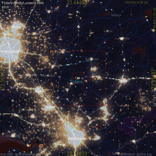
Analysis of Thāsra night lights 2016
Square area 10x10 km:
 0%
0%90-99
0%80-89
0.79%70-79
1.98%60-69
1.19%50-59
0%40-49
1.19%30-39
2.58%20-29
0.2%10-19
1.98%0-9
90.08%Square area 50x50 km:
0.11%90-99
0.87%80-89
0.68%70-79
0.61%60-69
1.24%50-59
1.96%40-49
1.86%30-39
2.4%20-29
2.95%10-19
6.34%0-9
80.98%Clear (daylight) street map image can be seen on geolist.org.
Map coordinates:
23° 26' 41.8" North, 72° 30' 31" East
22° 47' 53.9" North, 73° 12' 42.3" East
22° 8' 54.9" North, 73° 54' 53.5" East
Some cities around Thāsra sort by population:
• Nadiād
37.7 km =23.4 mi,  252°
252°
• Anand
37.9 km =23.5 mi,  223°
223°
• Kapadvanj
28.8 km =17.9 mi,  330°
330°
• Chaklāsi
31.8 km =19.8 mi,  239°
239°
• Umreth
14.8 km =9.2 mi, 221°
• Kālol
33.3 km =20.7 mi,  129°
129°
• Dākor
8.1 km =5 mi,  231°
231°
• Mahudha
27.9 km =17.3 mi,  275°
275°
1254624 (p: 18,337)
Sources (retrieved 2019-11-25):
» Earth at Night: Flat Maps 2012, 2016