Bhānpura night lights from space
Night Light of Bhānpura (Madhya Pradesh) from space (India) Src. Average luminocity for 10x10km area is 12.2837% and for 50x50km: 9.2744%.
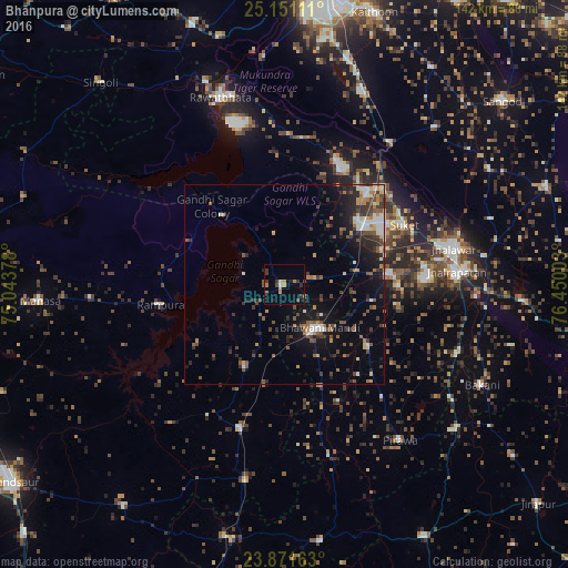
Analysis of Bhānpura night lights 2016
Square area 10x10 km:
 0%
0%90-99
0.79%80-89
0.79%70-79
2.58%60-69
2.18%50-59
1.39%40-49
1.59%30-39
5.95%20-29
2.58%10-19
1.59%0-9
80.56%Square area 50x50 km:
0.7%90-99
1.39%80-89
0.62%70-79
0.99%60-69
1.1%50-59
1.7%40-49
1.78%30-39
2.24%20-29
2.57%10-19
5.85%0-9
81.05%Clear (daylight) street map image can be seen on geolist.org.
Map coordinates:
25° 9' 4" North, 75° 2' 37.6" East
24° 30' 46.8" North, 75° 44' 48.8" East
23° 52' 17.9" North, 76° 27' 0.1" East
Some cities around Bhānpura sort by population:
• Bhawāniganj
14 km =8.7 mi,  140°
140°
• Rāmganj Mandi
24.8 km =15.4 mi,  53°
53°
• Shāmgarh
37.7 km =23.4 mi,  196°
196°
• Suket
33.3 km =20.7 mi,  63°
63°
• Rāmpura
31.5 km =19.6 mi,  260°
260°
• Sunel
26.5 km =16.5 mi,  126°
126°
• Chechat
31.4 km =19.5 mi,  26°
26°
• Udpura
33.7 km =20.9 mi,  43°
43°
1276152 (p: 17,082)
Sources (retrieved 2019-11-25):
» Earth at Night: Flat Maps 2012, 2016