Sompeta night lights from space
Night Light of Sompeta (Andhra Pradesh) from space (India) Src. Average luminocity for 10x10km area is 8.2186% and for 50x50km: 1.7371%.
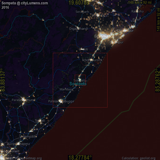
Analysis of Sompeta night lights 2016
Square area 10x10 km:
 0.65%
0.65%90-99
1.08%80-89
0.87%70-79
0%60-69
1.08%50-59
2.81%40-49
2.38%30-39
2.38%20-29
0%10-19
1.52%0-9
87.23%Square area 50x50 km:
0.04%90-99
0.25%80-89
0.16%70-79
0.01%60-69
0.16%50-59
0.43%40-49
0.34%30-39
0.68%20-29
0.43%10-19
0.66%0-9
96.82%Clear (daylight) street map image can be seen on geolist.org.
Map coordinates:
19° 36' 28.4" North, 83° 52' 52.9" East
18° 56' 39.1" North, 84° 35' 4.2" East
18° 16' 40.2" North, 85° 17' 15.4" East
Some cities around Sompeta sort by population:
• Brahmapur
46.3 km =28.8 mi,  28°
28°
• Palāsa
26.5 km =16.5 mi,  223°
223°
• Ichchāpuram
21.7 km =13.5 mi, 29°
• Tekkali
52.6 km =32.7 mi, 224°
• Digapahandi
47.7 km =29.6 mi,  358°
358°
• Chikitigarh
28.9 km =18 mi,  6°
6°
• Mandasa
15.3 km =9.5 mi,  236°
236°
• Gopālpur
48.6 km =30.2 mi,  43°
43°
1255816 (p: 17,982)
Sources (retrieved 2019-11-25):
» Earth at Night: Flat Maps 2012, 2016