Gopālpur night lights from space
Night Light of Gopālpur (Odisha) from space (India) Src. Average luminocity for 10x10km area is 34.6905% and for 50x50km: 12.3822%.
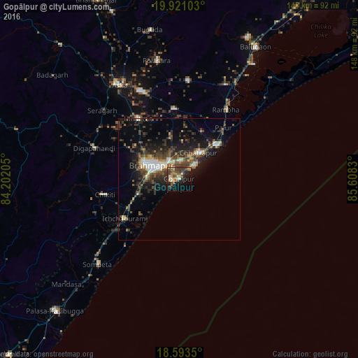
Analysis of Gopālpur night lights 2016
Square area 10x10 km:
 2.16%
2.16%90-99
3.9%80-89
2.81%70-79
6.28%60-69
5.84%50-59
7.58%40-49
10.39%30-39
10.17%20-29
6.28%10-19
21.21%0-9
23.38%Square area 50x50 km:
1%90-99
1.93%80-89
0.89%70-79
1.14%60-69
1.04%50-59
2.66%40-49
2.86%30-39
3.52%20-29
4.46%10-19
8.1%0-9
72.4%Clear (daylight) street map image can be seen on geolist.org.
Map coordinates:
19° 55' 15.7" North, 84° 12' 7.4" East
19° 15' 31" North, 84° 54' 18.6" East
18° 35' 36.6" North, 85° 36' 29.9" East
Some cities around Gopālpur sort by population:
• Brahmapur
13.2 km =8.2 mi,  296°
296°
• Ichchāpuram
28 km =17.4 mi,  234°
234°
• Hinjilikatu
30 km =18.6 mi,  325°
325°
• Chatrapur
13.6 km =8.5 mi,  37°
37°
• Purushottampur
29.2 km =18.1 mi,  355°
355°
• Ganjām
20.9 km =13 mi,  46°
46°
• Rambha
35.2 km =21.9 mi, 35°
• Chikitigarh
31.2 km =19.4 mi,  258°
258°
1270961 (p: 7,163)
Sources (retrieved 2019-11-25):
» Earth at Night: Flat Maps 2012, 2016