Singoli night lights from space
Night Light of Singoli (Madhya Pradesh) from space (India) Src. Average luminocity for 10x10km area is 3.1477% and for 50x50km: 2.0066%.
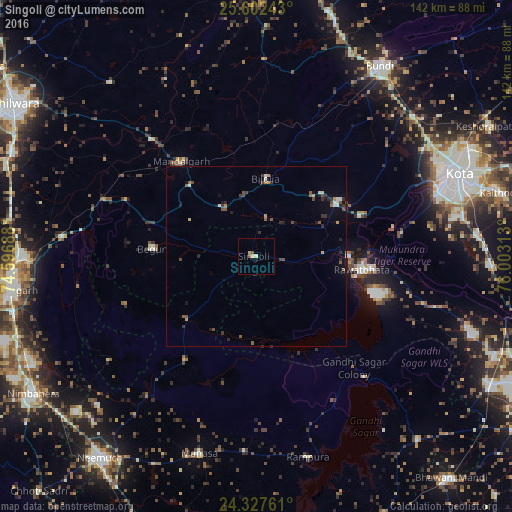
Analysis of Singoli night lights 2016
Square area 10x10 km:
 0%
0%90-99
0.38%80-89
1.14%70-79
0.76%60-69
0%50-59
0.76%40-49
0.76%30-39
0%20-29
0%10-19
0%0-9
96.21%Square area 50x50 km:
0.09%90-99
0.25%80-89
0.16%70-79
0.27%60-69
0.08%50-59
0.44%40-49
0.52%30-39
0.37%20-29
0.58%10-19
0.7%0-9
96.52%Clear (daylight) street map image can be seen on geolist.org.
Map coordinates:
25° 36' 8.7" North, 74° 35' 48.8" East
24° 58' 0" North, 75° 18' 0" East
24° 19' 39.4" North, 76° 0' 11.3" East
Some cities around Singoli sort by population:
• Kota
59.4 km =36.9 mi,  66°
66°
• Rāwatbhāta
29.7 km =18.5 mi,  97°
97°
• Manāsa
56.7 km =35.2 mi,  196°
196°
• Māndalgarh
34.1 km =21.2 mi,  317°
317°
• Begūn
30.3 km =18.8 mi,  273°
273°
• Rāmpura
57.3 km =35.6 mi,  165°
165°
• Jāwad
60.2 km =37.4 mi,  227°
227°
• Ratangarh
24.9 km =15.5 mi, 227°
1256146 (p: 9,030)
Sources (retrieved 2019-11-25):
» Earth at Night: Flat Maps 2012, 2016