Serula night lights from space
Night Light of Serula (Goa) from space (India) Src. Average luminocity for 10x10km area is 77.6948% and for 50x50km: 33.5515%.
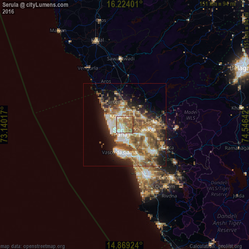
Analysis of Serula night lights 2016
Square area 10x10 km:
100  11.26%
90-99 20.78%
80-89 18.83%
70-79 10.82%
60-69 20.35%
50-59 15.15%
40-49 2.81%
30-39 0%
20-29 0%
10-19 0%
0-9 0%
11.26%90-99
20.78%80-89
18.83%70-79
10.82%60-69
20.35%50-59
15.15%40-49
2.81%30-39
0%20-29
0%10-19
0%0-9
0%Square area 50x50 km:
100 3.64%
90-99 7.41%
80-89 4.63%
70-79 3.6%
60-69 6.74%
50-59 8.55%
40-49 6.05%
30-39 4%
20-29 5.9%
10-19 8.63%
0-9 40.85%
3.64%90-99
7.41%80-89
4.63%70-79
3.6%60-69
6.74%50-59
8.55%40-49
6.05%30-39
4%20-29
5.9%10-19
8.63%0-9
40.85%Clear (daylight) street map image can be seen on geolist.org.
Map coordinates:
16° 13' 26.4" North, 73° 8' 24.6" East
15° 32' 51.9" North, 73° 50' 35.8" East
14° 52' 9.3" North, 74° 32' 47.1" East
Some cities around Serula sort by population:
• Panaji
6.1 km =3.8 mi,  197°
197°
• Māpuca
6.1 km =3.8 mi,  322°
322°
• Taleigao
8.8 km =5.5 mi,  187°
187°
• Candolim
9.3 km =5.8 mi,  249°
249°
• Guirim
4.9 km =3 mi,  308°
308°
• Aldona
6.1 km =3.8 mi,  33°
33°
• Saligao
5.7 km =3.5 mi,  276°
276°
• Bambolim
9.4 km =5.8 mi,  173°
173°
1256796 (p: 10,631)
Sources (retrieved 2019-11-25):
» Earth at Night: Flat Maps 2012, 2016