Guirim night lights from space
Night Light of Guirim (Goa) from space (India) Src. Average luminocity for 10x10km area is 86.2857% and for 50x50km: 30.5324%.
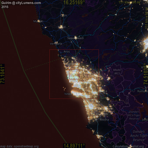
Analysis of Guirim night lights 2016
Square area 10x10 km:
100  16.45%
90-99 33.55%
80-89 25.32%
70-79 10.17%
60-69 8.87%
50-59 5.63%
40-49 0%
30-39 0%
20-29 0%
10-19 0%
0-9 0%
16.45%90-99
33.55%80-89
25.32%70-79
10.17%60-69
8.87%50-59
5.63%40-49
0%30-39
0%20-29
0%10-19
0%0-9
0%Square area 50x50 km:
100 3.63%
90-99 7.21%
80-89 4.38%
70-79 3.28%
60-69 5.91%
50-59 7.53%
40-49 5.41%
30-39 3.12%
20-29 4.4%
10-19 6.49%
0-9 48.65%
3.63%90-99
7.21%80-89
4.38%70-79
3.28%60-69
5.91%50-59
7.53%40-49
5.41%30-39
3.12%20-29
4.4%10-19
6.49%0-9
48.65%Clear (daylight) street map image can be seen on geolist.org.
Map coordinates:
16° 15' 6.1" North, 73° 6' 14.8" East
15° 34' 31.9" North, 73° 48' 26" East
14° 53' 49.6" North, 74° 30' 37.3" East
Some cities around Guirim sort by population:
• Māpuca
1.8 km =1.1 mi,  6°
6°
• Calangute
6.6 km =4.1 mi,  237°
237°
• Vagator
7.1 km =4.4 mi,  290°
290°
• Serula
4.9 km =3 mi,  128°
128°
• Solim
6.1 km =3.8 mi,  315°
315°
• Aldona
7.5 km =4.7 mi,  74°
74°
• Saligao
3 km =1.9 mi,  216°
216°
• Colovale
6.9 km =4.3 mi,  15°
15°
1270774 (p: 7,057)
Sources (retrieved 2019-11-25):
» Earth at Night: Flat Maps 2012, 2016