Aldona night lights from space
Night Light of Aldona (Goa) from space (India) Src. Average luminocity for 10x10km area is 69.355% and for 50x50km: 31.3438%.
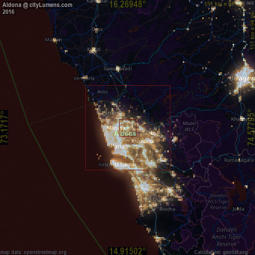
Analysis of Aldona night lights 2016
Square area 10x10 km:
100  1.52%
1.52%
90-99 13.2%
80-89 18.83%
70-79 11.26%
60-69 23.38%
50-59 20.13%
40-49 8.66%
30-39 2.16%
20-29 0.87%
10-19 0%
0-9 0%
1.52%90-99
13.2%80-89
18.83%70-79
11.26%60-69
23.38%50-59
20.13%40-49
8.66%30-39
2.16%20-29
0.87%10-19
0%0-9
0%Square area 50x50 km:
100 3.48%
90-99 7.16%
80-89 4.38%
70-79 3.47%
60-69 5.81%
50-59 7.74%
40-49 5.61%
30-39 3.63%
20-29 5.03%
10-19 8.83%
0-9 44.87%
3.48%90-99
7.16%80-89
4.38%70-79
3.47%60-69
5.81%50-59
7.74%40-49
5.61%30-39
3.63%20-29
5.03%10-19
8.83%0-9
44.87%Clear (daylight) street map image can be seen on geolist.org.
Map coordinates:
16° 16' 10.1" North, 73° 10' 18.1" East
15° 35' 36.1" North, 73° 52' 29.4" East
14° 54' 54.1" North, 74° 34' 40.6" East
Some cities around Aldona sort by population:
• Māpuca
7.1 km =4.4 mi,  268°
268°
• Dicholi
7.6 km =4.7 mi,  90°
90°
• Serula
6.1 km =3.8 mi,  213°
213°
• Solim
11.8 km =7.3 mi,  281°
281°
• Guirim
7.5 km =4.7 mi,  254°
254°
• Saligao
10.1 km =6.3 mi,  243°
243°
• Colovale
7.1 km =4.4 mi,  310°
310°
• Jua
10.7 km =6.6 mi,  130°
130°
1279045 (p: 6,606)
Sources (retrieved 2019-11-25):
» Earth at Night: Flat Maps 2012, 2016