Sanvordem night lights from space
Night Light of Sanvordem (Goa) from space (India) Src. Average luminocity for 10x10km area is 41.0702% and for 50x50km: 20.0503%.
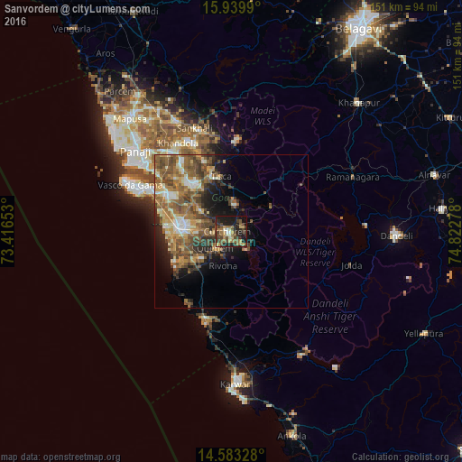
Analysis of Sanvordem night lights 2016
Square area 10x10 km:
 1.45%
1.45%90-99
4.55%80-89
4.96%70-79
6.4%60-69
7.64%50-59
10.33%40-49
10.95%30-39
9.5%20-29
16.12%10-19
24.59%0-9
3.51%Square area 50x50 km:
1.16%90-99
3.03%80-89
2.55%70-79
2.86%60-69
4.31%50-59
5.76%40-49
4.83%30-39
3.32%20-29
4.23%10-19
6.64%0-9
61.31%Clear (daylight) street map image can be seen on geolist.org.
Map coordinates:
15° 56' 23.6" North, 73° 24' 59.5" East
15° 15' 45.7" North, 74° 7' 10.7" East
14° 34' 59.8" North, 74° 49' 22" East
Some cities around Sanvordem sort by population:
• Madgaon
17.4 km =10.8 mi,  274°
274°
• Curchorem
1.2 km =0.7 mi, 274°
• Cuncolim
16.5 km =10.3 mi,  234°
234°
• Quepem
7.2 km =4.5 mi,  219°
219°
• Davorlim
13.7 km =8.5 mi, 274°
• Raia
16.6 km =10.3 mi,  286°
286°
• Chinchinim
16.4 km =10.2 mi,  250°
250°
• Sanguem
5.1 km =3.2 mi,  137°
137°
1257316 (p: 5,051)
Sources (retrieved 2019-11-25):
» Earth at Night: Flat Maps 2012, 2016