Davorlim night lights from space
Night Light of Davorlim (Goa) from space (India) Src. Average luminocity for 10x10km area is 71.2252% and for 50x50km: 26.3047%.
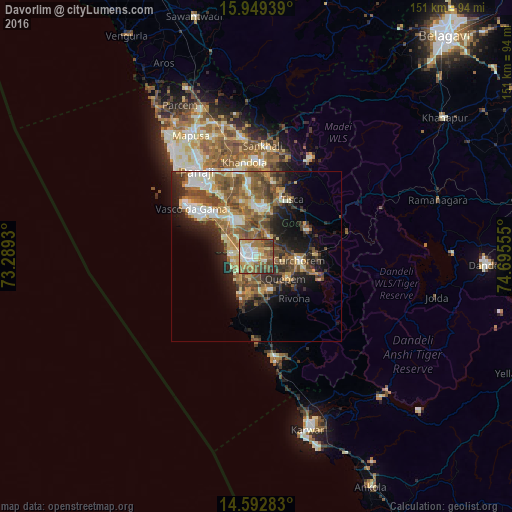
Analysis of Davorlim night lights 2016
Square area 10x10 km:
100  11.57%
90-99 19.21%
80-89 8.47%
70-79 11.57%
60-69 15.91%
50-59 13.64%
40-49 13.84%
30-39 4.55%
20-29 1.24%
10-19 0%
0-9 0%
11.57%90-99
19.21%80-89
8.47%70-79
11.57%60-69
15.91%50-59
13.64%40-49
13.84%30-39
4.55%20-29
1.24%10-19
0%0-9
0%Square area 50x50 km:
100 2.45%
90-99 4.94%
80-89 3.21%
70-79 3.28%
60-69 4.99%
50-59 6.53%
40-49 5.8%
30-39 3.96%
20-29 5.67%
10-19 8.81%
0-9 50.36%
2.45%90-99
4.94%80-89
3.21%70-79
3.28%60-69
4.99%50-59
6.53%40-49
5.8%30-39
3.96%20-29
5.67%10-19
8.81%0-9
50.36%Clear (daylight) street map image can be seen on geolist.org.
Map coordinates:
15° 56' 57.8" North, 73° 17' 21.5" East
15° 16' 20" North, 73° 59' 32.7" East
14° 35' 34.2" North, 74° 41' 44" East
Some cities around Davorlim sort by population:
• Madgaon
3.7 km =2.3 mi,  274°
274°
• Cuncolim
10.6 km =6.6 mi,  179°
179°
• Quepem
11.2 km =7 mi,  125°
125°
• Colva
7.5 km =4.7 mi,  276°
276°
• Benaulim
7 km =4.3 mi,  262°
262°
• Raia
4.3 km =2.7 mi,  327°
327°
• Chinchinim
6.7 km =4.2 mi,  195°
195°
• Varca
6.9 km =4.3 mi,  230°
230°
1273367 (p: 11,417)
Sources (retrieved 2019-11-25):
» Earth at Night: Flat Maps 2012, 2016