Sanguem night lights from space
Night Light of Sanguem (Goa) from space (India) Src. Average luminocity for 10x10km area is 26.2831% and for 50x50km: 16.4741%.
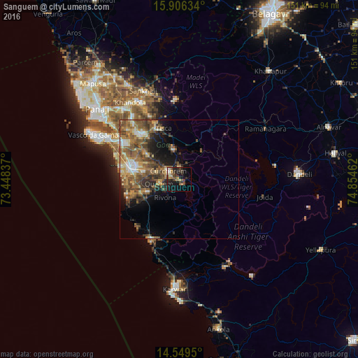
Analysis of Sanguem night lights 2016
Square area 10x10 km:
 1.03%
1.03%90-99
2.69%80-89
4.13%70-79
2.48%60-69
3.93%50-59
5.17%40-49
5.99%30-39
7.02%20-29
9.5%10-19
21.07%0-9
36.98%Square area 50x50 km:
1.09%90-99
2.46%80-89
1.9%70-79
2.34%60-69
3.6%50-59
4.45%40-49
3.94%30-39
3.09%20-29
3.32%10-19
5.57%0-9
68.25%Clear (daylight) street map image can be seen on geolist.org.
Map coordinates:
15° 54' 22.8" North, 73° 26' 54.1" East
15° 13' 44.4" North, 74° 9' 5.4" East
14° 32' 58.2" North, 74° 51' 16.6" East
Some cities around Sanguem sort by population:
• Madgaon
21.4 km =13.3 mi,  283°
283°
• Curchorem
6 km =3.7 mi,  309°
309°
• Cuncolim
17.9 km =11.1 mi,  251°
251°
• Quepem
8.2 km =5.1 mi,  257°
257°
• Davorlim
17.7 km =11 mi,  285°
285°
• Raia
21.1 km =13.1 mi, 293°
• Chinchinim
18.9 km =11.7 mi,  265°
265°
• Sanvordem
5.1 km =3.2 mi,  317°
317°
1257399 (p: 6,119)
Sources (retrieved 2019-11-25):
» Earth at Night: Flat Maps 2012, 2016