Sailāna night lights from space
Night Light of Sailāna (Madhya Pradesh) from space (India) Src. Average luminocity for 10x10km area is 8.2273% and for 50x50km: 7.8903%.
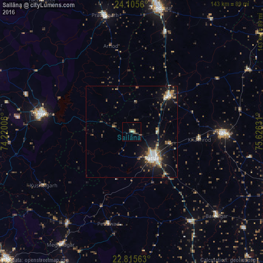
Analysis of Sailāna night lights 2016
Square area 10x10 km:
 0%
0%90-99
1.7%80-89
0.95%70-79
0%60-69
0.76%50-59
2.84%40-49
3.03%30-39
2.08%20-29
0.38%10-19
0.19%0-9
88.07%Square area 50x50 km:
0.62%90-99
1.4%80-89
0.7%70-79
0.6%60-69
1.02%50-59
1.4%40-49
1.39%30-39
1.77%20-29
2.12%10-19
6.58%0-9
82.41%Clear (daylight) street map image can be seen on geolist.org.
Map coordinates:
24° 6' 20.2" North, 74° 13' 12.2" East
23° 27' 43.9" North, 74° 55' 23.4" East
22° 48' 56.3" North, 75° 37' 34.7" East
Some cities around Sailāna sort by population:
• Ratlām
18.9 km =11.7 mi,  140°
140°
• Nagda
50.4 km =31.3 mi,  90°
90°
• Bānswāra
49.8 km =30.9 mi,  280°
280°
• Jaorā
28.5 km =17.7 mi,  46°
46°
• Khāchrod
36.8 km =22.9 mi,  96°
96°
• Petlāwad
51.8 km =32.2 mi,  194°
194°
• Namli
14 km =8.7 mi, 90°
• Bamna
44.1 km =27.4 mi,  201°
201°
1257765 (p: 10,810)
Sources (retrieved 2019-11-25):
» Earth at Night: Flat Maps 2012, 2016