Roha night lights from space
Night Light of Roha (Gujarat) from space (India) Src. Average luminocity for 10x10km area is 0.0076% and for 50x50km: 0.7344%.
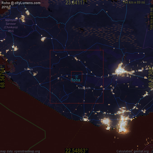
Analysis of Roha night lights 2016
Square area 10x10 km:
100  0%
0%
90-99 0%
80-89 0%
70-79 0%
60-69 0%
50-59 0%
40-49 0%
30-39 0%
20-29 0%
10-19 0%
0-9 100%
0%90-99
0%80-89
0%70-79
0%60-69
0%50-59
0%40-49
0%30-39
0%20-29
0%10-19
0%0-9
100%Square area 50x50 km:
100 0%
90-99 0%
80-89 0%
70-79 0.06%
60-69 0.22%
50-59 0.29%
40-49 0.18%
30-39 0.25%
20-29 0.45%
10-19 0.2%
0-9 98.35%
0%90-99
0%80-89
0%70-79
0.06%60-69
0.22%50-59
0.29%40-49
0.18%30-39
0.25%20-29
0.45%10-19
0.2%0-9
98.35%Clear (daylight) street map image can be seen on geolist.org.
Map coordinates:
23° 50' 28.2" North, 68° 34' 3.5" East
23° 11' 47.3" North, 69° 16' 14.7" East
22° 32' 55.1" North, 69° 58' 26" East
Some cities around Roha sort by population:
• Gāndhīdhām
89.1 km =55.4 mi,  98°
98°
• Bhuj
41.2 km =25.6 mi,  81°
81°
• Anjār
77.8 km =48.3 mi, 96°
• Māndvi
41.3 km =25.7 mi,  168°
168°
• Okha
83.6 km =51.9 mi,  194°
194°
• Mundra
60.9 km =37.8 mi,  130°
130°
• Dayapar
61.5 km =38.2 mi,  322°
322°
• Naliya
45.9 km =28.5 mi,  278°
278°
1258098 (p: 8,664)
Sources (retrieved 2019-11-25):
» Earth at Night: Flat Maps 2012, 2016