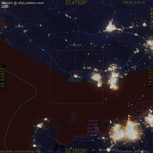
Māndvi night lights from space
Night Light of Māndvi (Gujarat) from space (India) Src. Average luminocity for 10x10km area is 14.1647% and for 50x50km: 4.2481%.
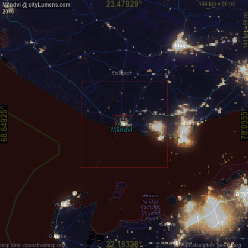
Analysis of Māndvi night lights 2016
Square area 10x10 km:
100  0.4%
0.4%
90-99 2.78%
80-89 1.59%
70-79 1.39%
60-69 0.6%
50-59 2.78%
40-49 5.56%
30-39 2.38%
20-29 2.38%
10-19 1.98%
0-9 78.17%
0.4%90-99
2.78%80-89
1.59%70-79
1.39%60-69
0.6%50-59
2.78%40-49
5.56%30-39
2.38%20-29
2.38%10-19
1.98%0-9
78.17%Square area 50x50 km:
100 0.4%
90-99 0.9%
80-89 0.21%
70-79 0.36%
60-69 0.56%
50-59 0.56%
40-49 0.84%
30-39 0.93%
20-29 1.27%
10-19 3.07%
0-9 90.88%
0.4%90-99
0.9%80-89
0.21%70-79
0.36%60-69
0.56%50-59
0.56%40-49
0.84%30-39
0.93%20-29
1.27%10-19
3.07%0-9
90.88%Clear (daylight) street map image can be seen on geolist.org.
Map coordinates:
23° 28' 45.4" North, 68° 38' 57.3" East
22° 49' 58.2" North, 69° 21' 8.5" East
22° 10' 59.7" North, 70° 3' 19.8" East
Some cities around Māndvi sort by population:
• Bhuj
57 km =35.4 mi,  34°
34°
• Anjār
75.7 km =47 mi,  65°
65°
• Salāya
63.6 km =39.5 mi,  156°
156°
• Okha
49.9 km =31 mi,  215°
215°
• Sikka
67.1 km =41.7 mi,  131°
131°
• Mundra
37.9 km =23.5 mi,  88°
88°
• Naliya
71.8 km =44.6 mi,  311°
311°
• Roha
41.3 km =25.7 mi,  348°
348°
1263824 (p: 47,853)
Sources (retrieved 2019-11-25):
» Earth at Night: Flat Maps 2012, 2016