Rāzole night lights from space
Night Light of Rāzole (Andhra Pradesh) from space (India) Src. Average luminocity for 10x10km area is 31.2211% and for 50x50km: 15.2245%.
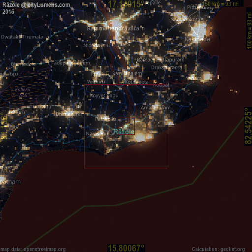
Analysis of Rāzole night lights 2016
Square area 10x10 km:
 0%
0%90-99
1.65%80-89
1.65%70-79
3.31%60-69
4.34%50-59
5.99%40-49
14.88%30-39
10.95%20-29
17.15%10-19
31.4%0-9
8.68%Square area 50x50 km:
0.38%90-99
1.77%80-89
0.9%70-79
1.47%60-69
2.14%50-59
2.74%40-49
4.37%30-39
3.98%20-29
6.6%10-19
15.35%0-9
60.29%Clear (daylight) street map image can be seen on geolist.org.
Map coordinates:
17° 8' 56.9" North, 81° 8' 9.6" East
16° 28' 33.9" North, 81° 50' 20.8" East
15° 48' 2.4" North, 82° 32' 32.1" East
Some cities around Rāzole sort by population:
• Bhīmavaram
34.4 km =21.4 mi,  282°
282°
• Tanuku
35.2 km =21.9 mi,  331°
331°
• Attili
35.6 km =22.1 mi,  314°
314°
• Narasapur
15.7 km =9.8 mi,  252°
252°
• Pālakollu
12.5 km =7.8 mi,  291°
291°
• Amalāpuram
21.1 km =13.1 mi,  57°
57°
• Penugonda
22.1 km =13.7 mi, 333°
• Pippara
40.8 km =25.4 mi, 310°
1258269 (p: 14,204)
Sources (retrieved 2019-11-25):
» Earth at Night: Flat Maps 2012, 2016