Jākhal night lights from space
Night Light of Jākhal (Haryana) from space (India) Src. Average luminocity for 10x10km area is 15.3214% and for 50x50km: 9.7009%.
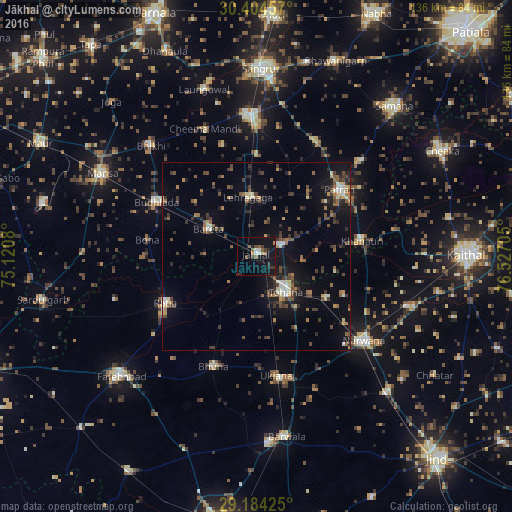
Analysis of Jākhal night lights 2016
Square area 10x10 km:
 1.98%
1.98%90-99
1.19%80-89
0.79%70-79
0.2%60-69
2.58%50-59
3.17%40-49
1.59%30-39
3.77%20-29
3.17%10-19
19.44%0-9
62.1%Square area 50x50 km:
0.41%90-99
1.1%80-89
0.79%70-79
0.65%60-69
1.38%50-59
1.82%40-49
2.07%30-39
2.46%20-29
2.41%10-19
6.86%0-9
80.06%Clear (daylight) street map image can be seen on geolist.org.
Map coordinates:
30° 24' 16.5" North, 75° 7' 14.9" East
29° 47' 46.6" North, 75° 49' 26.1" East
29° 11' 3.3" North, 76° 31' 37.4" East
Some cities around Jākhal sort by population:
• Tohāna
12.1 km =7.5 mi,  139°
139°
• Narwāna
36 km =22.4 mi,  127°
127°
• Ratia
26.6 km =16.5 mi,  243°
243°
• Budhlāda
29.2 km =18.1 mi,  300°
300°
• Dirba
34.9 km =21.7 mi,  28°
28°
• Uklāna
32.1 km =19.9 mi,  170°
170°
• Inda Chhoi
17.6 km =10.9 mi,  190°
190°
• Akālgarh
7 km =4.3 mi,  67°
67°
1269470 (p: 7,411)
Sources (retrieved 2019-11-25):
» Earth at Night: Flat Maps 2012, 2016