Rāmnagar night lights from space
Night Light of Rāmnagar (Uttar Pradesh) from space (India) Src. Average luminocity for 10x10km area is 11.2386% and for 50x50km: 9.9595%.
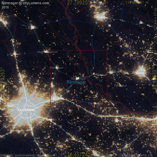
Analysis of Rāmnagar night lights 2016
Square area 10x10 km:
 1.52%
1.52%90-99
0.76%80-89
2.27%70-79
0.76%60-69
1.52%50-59
1.33%40-49
1.7%30-39
2.27%20-29
2.27%10-19
3.22%0-9
82.39%Square area 50x50 km:
0.66%90-99
1.28%80-89
0.84%70-79
0.7%60-69
1.23%50-59
1.78%40-49
2.65%30-39
2.68%20-29
3.95%10-19
5.31%0-9
78.93%Clear (daylight) street map image can be seen on geolist.org.
Map coordinates:
27° 42' 33.3" North, 80° 42' 9.5" East
27° 5' 6" North, 81° 24' 20.7" East
26° 27' 26.1" North, 82° 6' 32" East
Some cities around Rāmnagar sort by population:
• Nawābganj
26.7 km =16.6 mi,  230°
230°
• Fatehpur
21.6 km =13.4 mi,  296°
296°
• Zaidpur
29.2 km =18.1 mi,  195°
195°
• Colonelganj
29.5 km =18.3 mi,  79°
79°
• Jarwal
16 km =9.9 mi,  57°
57°
• Dewā
24.3 km =15.1 mi,  257°
257°
• Satrikh
32.5 km =20.2 mi,  219°
219°
• Tikaitnagar
22.1 km =13.7 mi,  134°
134°
1258640 (p: 13,490)
Sources (retrieved 2019-11-25):
» Earth at Night: Flat Maps 2012, 2016