Rāmamangalam night lights from space
Night Light of Rāmamangalam (Kerala) from space (India) Src. Average luminocity for 10x10km area is 0.3595% and for 50x50km: 16.5417%.
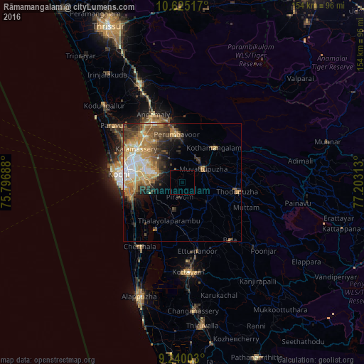
Analysis of Rāmamangalam night lights 2016
Square area 10x10 km:
 0%
0%90-99
0%80-89
0%70-79
0%60-69
0%50-59
0%40-49
0%30-39
0%20-29
0%10-19
0%0-9
100%Square area 50x50 km:
1.88%90-99
3.01%80-89
2.47%70-79
3.53%60-69
2.87%50-59
2.48%40-49
2.96%30-39
2.85%20-29
2.35%10-19
3.92%0-9
71.68%Clear (daylight) street map image can be seen on geolist.org.
Map coordinates:
10° 37' 30.6" North, 75° 47' 48.8" East
9° 55' 60" North, 76° 30' 0" East
9° 14' 24.1" North, 77° 12' 11.3" East
Some cities around Rāmamangalam sort by population:
• Kotamangalam
20.2 km =12.6 mi,  43°
43°
• Mūvattupula
10.2 km =6.3 mi,  55°
55°
• Muvattupuzha
9.6 km =6 mi, 57°
• Piravam
7.4 km =4.6 mi,  180°
180°
• Perumpāvūr
20.4 km =12.7 mi,  352°
352°
• Perumbavoor
19.5 km =12.1 mi, 351°
• Kumbalam
20.9 km =13 mi,  261°
261°
• Arukutti
18 km =11.2 mi,  245°
245°
1258747 (p: 9,999)
Sources (retrieved 2019-11-25):
» Earth at Night: Flat Maps 2012, 2016