Bandora night lights from space
Night Light of Bandora (Goa) from space (India) Src. Average luminocity for 10x10km area is 69.1926% and for 50x50km: 39.3328%.
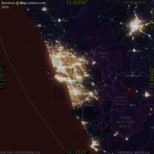
Analysis of Bandora night lights 2016
Square area 10x10 km:
100  7.58%
7.58%
90-99 16.02%
80-89 7.36%
70-79 9.52%
60-69 23.38%
50-59 22.73%
40-49 9.74%
30-39 3.46%
20-29 0.22%
10-19 0%
0-9 0%
7.58%90-99
16.02%80-89
7.36%70-79
9.52%60-69
23.38%50-59
22.73%40-49
9.74%30-39
3.46%20-29
0.22%10-19
0%0-9
0%Square area 50x50 km:
100 4.13%
90-99 8.42%
80-89 5.71%
70-79 4.91%
60-69 7.75%
50-59 9.72%
40-49 6.94%
30-39 4.72%
20-29 6.78%
10-19 9.91%
0-9 31%
4.13%90-99
8.42%80-89
5.71%70-79
4.91%60-69
7.75%50-59
9.72%40-49
6.94%30-39
4.72%20-29
6.78%10-19
9.91%0-9
31%Clear (daylight) street map image can be seen on geolist.org.
Map coordinates:
16° 5' 5.9" North, 73° 16' 41.4" East
15° 24' 29.6" North, 73° 58' 52.6" East
14° 43' 45.4" North, 74° 41' 3.9" East
Some cities around Bandora sort by population:
• Ponda
3.7 km =2.3 mi,  98°
98°
• Sancoale
9 km =5.6 mi,  248°
248°
• Curti
3.9 km =2.4 mi,  76°
76°
• Raia
11.5 km =7.1 mi,  185°
185°
• Cortalim
7.8 km =4.8 mi,  265°
265°
• Queula
2.1 km =1.3 mi,  167°
167°
• Goa Velha
11 km =6.8 mi,  291°
291°
• Palle
12.7 km =7.9 mi,  59°
59°
1277353 (p: 12,819)
Sources (retrieved 2019-11-25):
» Earth at Night: Flat Maps 2012, 2016