Pāpireddippatti night lights from space
Night Light of Pāpireddippatti (Tamil Nadu) from space (India) Src. Average luminocity for 10x10km area is 1.4835% and for 50x50km: 4.2101%.
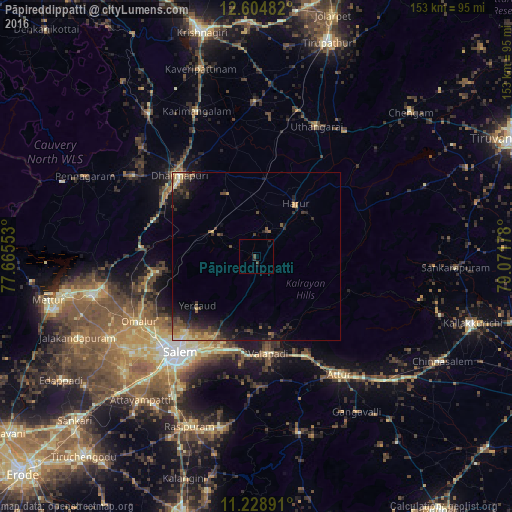
Analysis of Pāpireddippatti night lights 2016
Square area 10x10 km:
 0%
0%90-99
0%80-89
0%70-79
0%60-69
0%50-59
0%40-49
1.65%30-39
0.83%20-29
0.83%10-19
0.83%0-9
95.87%Square area 50x50 km:
0.04%90-99
0.27%80-89
0.72%70-79
0.55%60-69
0.63%50-59
0.66%40-49
1.2%30-39
1.15%20-29
1.47%10-19
3.26%0-9
90.04%Clear (daylight) street map image can be seen on geolist.org.
Map coordinates:
12° 36' 17.4" North, 77° 39' 55.9" East
11° 55' 3.9" North, 78° 22' 7.1" East
11° 13' 44.1" North, 79° 4' 18.4" East
Some cities around Pāpireddippatti sort by population:
• Salem
37.4 km =23.2 mi,  218°
218°
• Dharmapuri
32.7 km =20.3 mi,  315°
315°
• Attur
44 km =27.3 mi,  144°
144°
• Pallippatti
4.4 km =2.7 mi,  55°
55°
• Harūr
19.3 km =12 mi,  38°
38°
• Omalur
40.3 km =25 mi,  240°
240°
• Mallāpuram
15 km =9.3 mi,  298°
298°
• Belūr
23.9 km =14.9 mi,  167°
167°
1260410 (p: 8,852)
Sources (retrieved 2019-11-25):
» Earth at Night: Flat Maps 2012, 2016