Belūr night lights from space
Night Light of Belūr (Tamil Nadu) from space (India) Src. Average luminocity for 10x10km area is 14.1983% and for 50x50km: 9.9093%.
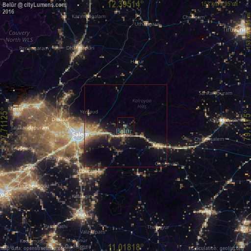
Analysis of Belūr night lights 2016
Square area 10x10 km:
 0%
0%90-99
0%80-89
0%70-79
0%60-69
1.65%50-59
2.07%40-49
7.64%30-39
5.37%20-29
8.88%10-19
20.04%0-9
54.34%Square area 50x50 km:
0.03%90-99
0.78%80-89
1.71%70-79
1.11%60-69
1.24%50-59
1.65%40-49
2.77%30-39
2.42%20-29
3.64%10-19
9.5%0-9
75.14%Clear (daylight) street map image can be seen on geolist.org.
Map coordinates:
12° 23' 42.5" North, 77° 42' 40.5" East
11° 42' 27.1" North, 78° 24' 51.7" East
11° 1' 5.4" North, 79° 7' 3" East
Some cities around Belūr sort by population:
• Salem
28.8 km =17.9 mi,  258°
258°
• Attur
24 km =14.9 mi,  121°
121°
• Pallippatti
25.9 km =16.1 mi,  356°
356°
• Nāmagiripettai
32.3 km =20.1 mi,  209°
209°
• Mallāpuram
35.5 km =22.1 mi,  329°
329°
• Gangavalli
34.6 km =21.5 mi,  132°
132°
• Māllūr
34.9 km =21.7 mi,  238°
238°
• Pāpireddippatti
23.9 km =14.9 mi,  347°
347°
1276487 (p: 9,281)
Sources (retrieved 2019-11-25):
» Earth at Night: Flat Maps 2012, 2016