Omalur night lights from space
Night Light of Omalur (Tamil Nadu) from space (India) Src. Average luminocity for 10x10km area is 67.5186% and for 50x50km: 37.9141%.
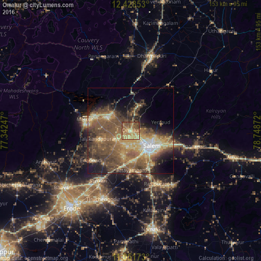
Analysis of Omalur night lights 2016
Square area 10x10 km:
 0%
0%90-99
3.51%80-89
18.39%70-79
25.21%60-69
22.52%50-59
21.28%40-49
8.26%30-39
0.83%20-29
0%10-19
0%0-9
0%Square area 50x50 km:
1.71%90-99
3.97%80-89
6.94%70-79
6.1%60-69
7.82%50-59
12.15%40-49
11.28%30-39
6.66%20-29
5.92%10-19
8.26%0-9
29.2%Clear (daylight) street map image can be seen on geolist.org.
Map coordinates:
12° 25' 42.7" North, 77° 20' 32.9" East
11° 44' 27.6" North, 78° 2' 44.1" East
11° 3' 6.2" North, 78° 44' 55.4" East
Some cities around Omalur sort by population:
• Salem
15.4 km =9.6 mi,  129°
129°
• Tāramangalam
9.7 km =6 mi,  237°
237°
• Jalakandapuram
19.4 km =12.1 mi,  255°
255°
• Āttayyāmpatti
23.2 km =14.4 mi,  177°
177°
• Ilampillai
15.5 km =9.6 mi,  195°
195°
• Māllūr
24.2 km =15 mi,  154°
154°
• Nangavalli
17 km =10.6 mi,  277°
277°
• Konganāpuram
24.6 km =15.3 mi,  219°
219°
1261049 (p: 12,701)
Sources (retrieved 2019-11-25):
» Earth at Night: Flat Maps 2012, 2016