Pālakkodu night lights from space
Night Light of Pālakkodu (Tamil Nadu) from space (India) Src. Average luminocity for 10x10km area is 10.2603% and for 50x50km: 7.1428%.
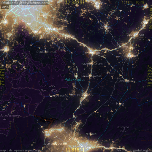
Analysis of Pālakkodu night lights 2016
Square area 10x10 km:
 0%
0%90-99
0.83%80-89
0.83%70-79
0.83%60-69
0.21%50-59
2.27%40-49
4.34%30-39
1.45%20-29
5.79%10-19
4.55%0-9
78.93%Square area 50x50 km:
0.11%90-99
0.44%80-89
0.74%70-79
0.49%60-69
0.72%50-59
1.48%40-49
1.99%30-39
2.29%20-29
3.38%10-19
5.93%0-9
82.43%Clear (daylight) street map image can be seen on geolist.org.
Map coordinates:
12° 59' 34.8" North, 77° 22' 1.6" East
12° 18' 25.1" North, 78° 4' 12.8" East
11° 37' 8.8" North, 78° 46' 24.1" East
Some cities around Pālakkodu sort by population:
• Krishnagiri
28.3 km =17.6 mi,  33°
33°
• Dharmapuri
22.1 km =13.7 mi,  154°
154°
• Denkanikota
39.4 km =24.5 mi,  309°
309°
• Pennāgaram
27 km =16.8 mi,  224°
224°
• Kāveripatnam
20.6 km =12.8 mi,  51°
51°
• Pāppārappatti
9.6 km =6 mi,  187°
187°
• Kelamangalam
40.6 km =25.2 mi,  324°
324°
• Mārāndahalli
11.6 km =7.2 mi, 321°
1260793 (p: 19,630)
Sources (retrieved 2019-11-25):
» Earth at Night: Flat Maps 2012, 2016