Pāppārappatti night lights from space
Night Light of Pāppārappatti (Tamil Nadu) from space (India) Src. Average luminocity for 10x10km area is 8.1178% and for 50x50km: 5.9082%.
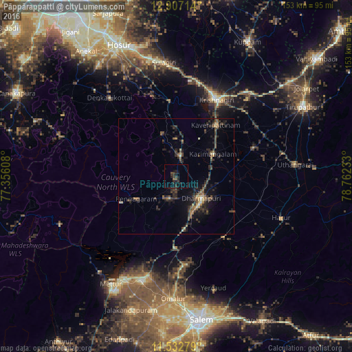
Analysis of Pāppārappatti night lights 2016
Square area 10x10 km:
 0%
0%90-99
0%80-89
0%70-79
0%60-69
0.83%50-59
1.03%40-49
2.07%30-39
4.75%20-29
7.85%10-19
5.58%0-9
77.89%Square area 50x50 km:
0.03%90-99
0.34%80-89
0.58%70-79
0.36%60-69
0.67%50-59
1.26%40-49
1.63%30-39
1.84%20-29
2.85%10-19
4.27%0-9
86.17%Clear (daylight) street map image can be seen on geolist.org.
Map coordinates:
12° 54' 25.7" North, 77° 21' 21.9" East
12° 13' 15.1" North, 78° 3' 33.1" East
11° 31' 58" North, 78° 45' 44.4" East
Some cities around Pāppārappatti sort by population:
• Krishnagiri
37.2 km =23.1 mi,  26°
26°
• Dharmapuri
14.9 km =9.3 mi,  133°
133°
• Pālakkodu
9.6 km =6 mi,  7°
7°
• Denkanikota
45.2 km =28.1 mi,  319°
319°
• Pennāgaram
20.3 km =12.6 mi,  241°
241°
• Kāveripatnam
28.3 km =17.6 mi,  37°
37°
• Mallāpuram
33.5 km =20.8 mi,  142°
142°
• Mārāndahalli
19.6 km =12.2 mi,  341°
341°
1260407 (p: 11,617)
Sources (retrieved 2019-11-25):
» Earth at Night: Flat Maps 2012, 2016