Mārāndahalli night lights from space
Night Light of Mārāndahalli (Tamil Nadu) from space (India) Src. Average luminocity for 10x10km area is 3.4711% and for 50x50km: 6.7995%.
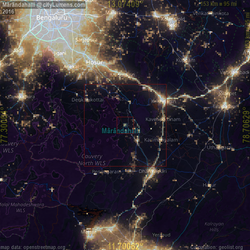
Analysis of Mārāndahalli night lights 2016
Square area 10x10 km:
 0%
0%90-99
0%80-89
0%70-79
0%60-69
0%50-59
2.48%40-49
0.83%30-39
0.83%20-29
1.65%10-19
1.86%0-9
92.36%Square area 50x50 km:
0.09%90-99
0.49%80-89
0.65%70-79
0.59%60-69
0.43%50-59
1.38%40-49
1.79%30-39
2.28%20-29
2.93%10-19
5.92%0-9
83.45%Clear (daylight) street map image can be seen on geolist.org.
Map coordinates:
13° 4' 26.7" North, 77° 18' 0.1" East
12° 23' 17.7" North, 78° 0' 11.4" East
11° 42' 2.2" North, 78° 42' 22.6" East
Some cities around Mārāndahalli sort by population:
• Krishnagiri
27.1 km =16.8 mi,  57°
57°
• Dharmapuri
33.5 km =20.8 mi,  149°
149°
• Pālakkodu
11.6 km =7.2 mi,  141°
141°
• Denkanikota
28.1 km =17.5 mi,  304°
304°
• Pennāgaram
30.6 km =19 mi,  202°
202°
• Kāveripatnam
23.7 km =14.7 mi,  80°
80°
• Pāppārappatti
19.6 km =12.2 mi,  161°
161°
• Kelamangalam
29 km =18 mi,  325°
325°
1263557 (p: 10,480)
Sources (retrieved 2019-11-25):
» Earth at Night: Flat Maps 2012, 2016