Kelamangalam night lights from space
Night Light of Kelamangalam (Tamil Nadu) from space (India) Src. Average luminocity for 10x10km area is 20.5152% and for 50x50km: 25.099%.
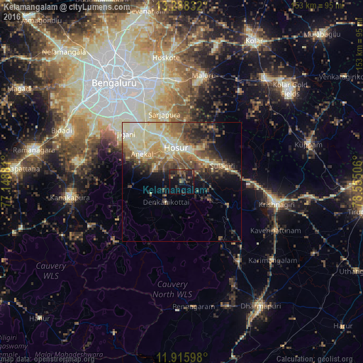
Analysis of Kelamangalam night lights 2016
Square area 10x10 km:
 0%
0%90-99
0%80-89
0.87%70-79
0.65%60-69
2.6%50-59
6.06%40-49
6.28%30-39
8.23%20-29
16.88%10-19
18.83%0-9
39.61%Square area 50x50 km:
1.38%90-99
5.87%80-89
5.94%70-79
2.61%60-69
3.21%50-59
4.87%40-49
5.05%30-39
4.25%20-29
4.3%10-19
7.4%0-9
55.12%Clear (daylight) street map image can be seen on geolist.org.
Map coordinates:
13° 17' 18" North, 77° 8' 55.7" East
12° 36' 11.1" North, 77° 51' 6.9" East
11° 54' 57.5" North, 78° 33' 18.2" East
Some cities around Kelamangalam sort by population:
• Hosūr
15 km =9.3 mi,  351°
351°
• Krishnagiri
40.4 km =25.1 mi,  103°
103°
• Anekal
20.8 km =12.9 mi,  305°
305°
• Mālūr
45.5 km =28.3 mi,  11°
11°
• Pālakkodu
40.6 km =25.2 mi,  144°
144°
• Denkanikota
10.6 km =6.6 mi,  220°
220°
• Kāveripatnam
44.6 km =27.7 mi,  116°
116°
• Mārāndahalli
29 km =18 mi,  145°
145°
1267331 (p: 11,328)
Sources (retrieved 2019-11-25):
» Earth at Night: Flat Maps 2012, 2016