Āttayyāmpatti night lights from space
Night Light of Āttayyāmpatti (Tamil Nadu) from space (India) Src. Average luminocity for 10x10km area is 51.5216% and for 50x50km: 42.8641%.
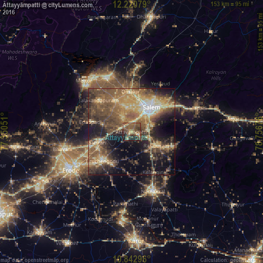
Analysis of Āttayyāmpatti night lights 2016
Square area 10x10 km:
 0%
0%90-99
4.11%80-89
6.06%70-79
7.79%60-69
11.47%50-59
27.92%40-49
17.53%30-39
8.87%20-29
11.26%10-19
4.98%0-9
0%Square area 50x50 km:
1.66%90-99
4.3%80-89
7.98%70-79
7.26%60-69
8.27%50-59
12.04%40-49
11.53%30-39
8.97%20-29
9.17%10-19
14.29%0-9
14.52%Clear (daylight) street map image can be seen on geolist.org.
Map coordinates:
12° 13' 14.8" North, 77° 21' 1.8" East
11° 31' 57.8" North, 78° 3' 13.1" East
10° 50' 34.7" North, 78° 45' 24.3" East
Some cities around Āttayyāmpatti sort by population:
• Salem
17.4 km =10.8 mi,  39°
39°
• Rasipuram
16.6 km =10.3 mi,  119°
119°
• Tāramangalam
20.1 km =12.5 mi,  333°
333°
• Mallasamudram
5 km =3.1 mi,  209°
209°
• Omalur
23.2 km =14.4 mi,  357°
357°
• Ilampillai
9.7 km =6 mi, 328°
• Māllūr
9.6 km =6 mi,  82°
82°
• Konganāpuram
17.2 km =10.7 mi,  284°
284°
1278182 (p: 13,627)
Sources (retrieved 2019-11-25):
» Earth at Night: Flat Maps 2012, 2016