Konganāpuram night lights from space
Night Light of Konganāpuram (Tamil Nadu) from space (India) Src. Average luminocity for 10x10km area is 35.0541% and for 50x50km: 42.1909%.
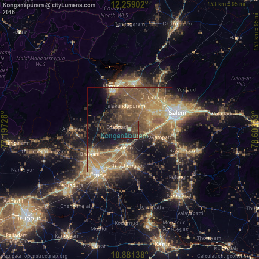
Analysis of Konganāpuram night lights 2016
Square area 10x10 km:
 0%
0%90-99
0.87%80-89
0.87%70-79
1.08%60-69
1.52%50-59
7.14%40-49
25.11%30-39
28.79%20-29
15.58%10-19
19.05%0-9
0%Square area 50x50 km:
0.67%90-99
3.89%80-89
7.83%70-79
7.34%60-69
9.3%50-59
13.89%40-49
11.68%30-39
7.81%20-29
7.66%10-19
12.75%0-9
17.19%Clear (daylight) street map image can be seen on geolist.org.
Map coordinates:
12° 15' 32.5" North, 77° 11' 50.2" East
11° 34' 15.8" North, 77° 54' 1.4" East
10° 52' 53" North, 78° 36' 12.7" East
Some cities around Konganāpuram sort by population:
• Tiruchengode
21.2 km =13.2 mi,  181°
181°
• Idappadi
6.9 km =4.3 mi,  284°
284°
• Tāramangalam
15.7 km =9.8 mi,  29°
29°
• Mallasamudram
16.7 km =10.4 mi,  121°
121°
• Jalakandapuram
14.4 km =8.9 mi,  348°
348°
• Āttayyāmpatti
17.2 km =10.7 mi,  104°
104°
• Ilampillai
12.2 km =7.6 mi,  71°
71°
• Ammāpettai
18 km =11.2 mi,  287°
287°
1266189 (p: 8,331)
Sources (retrieved 2019-11-25):
» Earth at Night: Flat Maps 2012, 2016