Ilampillai night lights from space
Night Light of Ilampillai (Tamil Nadu) from space (India) Src. Average luminocity for 10x10km area is 63.5887% and for 50x50km: 46.1589%.
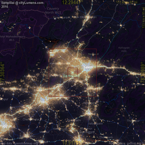
Analysis of Ilampillai night lights 2016
Square area 10x10 km:
 0%
0%90-99
2.38%80-89
11.26%70-79
12.55%60-69
33.12%50-59
29.44%40-49
11.26%30-39
0%20-29
0%10-19
0%0-9
0%Square area 50x50 km:
1.73%90-99
5.15%80-89
8.48%70-79
7.47%60-69
9%50-59
14.8%40-49
12.44%30-39
8.87%20-29
8.95%10-19
12.73%0-9
10.39%Clear (daylight) street map image can be seen on geolist.org.
Map coordinates:
12° 17' 40.1" North, 77° 18' 13.1" East
11° 36' 23.7" North, 78° 0' 24.3" East
10° 55' 1.2" North, 78° 42' 35.6" East
Some cities around Ilampillai sort by population:
• Salem
17 km =10.6 mi,  72°
72°
• Tāramangalam
10.5 km =6.5 mi,  337°
337°
• Mallasamudram
12.9 km =8 mi,  168°
168°
• Jalakandapuram
17.8 km =11.1 mi,  304°
304°
• Āttayyāmpatti
9.7 km =6 mi,  148°
148°
• Omalur
15.5 km =9.6 mi,  15°
15°
• Māllūr
16.2 km =10.1 mi,  115°
115°
• Konganāpuram
12.2 km =7.6 mi,  251°
251°
1269792 (p: 11,308)
Sources (retrieved 2019-11-25):
» Earth at Night: Flat Maps 2012, 2016