Norīa night lights from space
Night Light of Norīa (Jammu and Kashmir) from space (India) Src. Average luminocity for 10x10km area is 50.4615% and for 50x50km: 29.8873%.
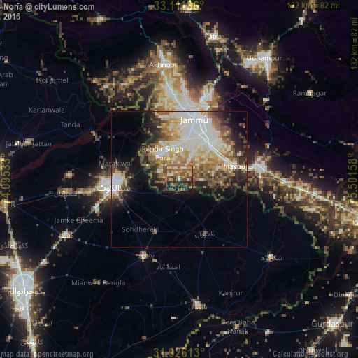
Analysis of Norīa night lights 2016
Square area 10x10 km:
 2.56%
2.56%90-99
7.69%80-89
4.76%70-79
9.89%60-69
9.16%50-59
16.48%40-49
13.55%30-39
9.71%20-29
12.82%10-19
12.82%0-9
0.55%Square area 50x50 km:
5.1%90-99
8.11%80-89
3.2%70-79
3.66%60-69
4.64%50-59
4.24%40-49
4.49%30-39
3.68%20-29
5.22%10-19
7.64%0-9
50.02%Clear (daylight) street map image can be seen on geolist.org.
Map coordinates:
33° 6' 42.7" North, 74° 5' 43.2" East
32° 31' 15.4" North, 74° 47' 54.4" East
31° 55' 34.1" North, 75° 30' 5.7" East
Some cities around Norīa sort by population:
• Sialkot, PK
25.2 km =15.7 mi,  262°
262°
• Jammu
24.8 km =15.4 mi,  15°
15°
• Hadali, PK
25.3 km =15.7 mi,  301°
301°
• Chawinda, PK
21.5 km =13.4 mi,  204°
204°
• Zafarwal, PK
21.8 km =13.5 mi,  154°
154°
• Kotli Loharan, PK
29.5 km =18.3 mi,  284°
284°
• Bishnāh
11.3 km =7 mi,  28°
28°
• Khaur
9.1 km =5.7 mi,  6°
6°
1278373 (p: 9,662)
Sources (retrieved 2019-11-25):
» Earth at Night: Flat Maps 2012, 2016