Nārsingi night lights from space
Night Light of Nārsingi (Telangana) from space (India) Src. Average luminocity for 10x10km area is 18.3528% and for 50x50km: 12.915%.
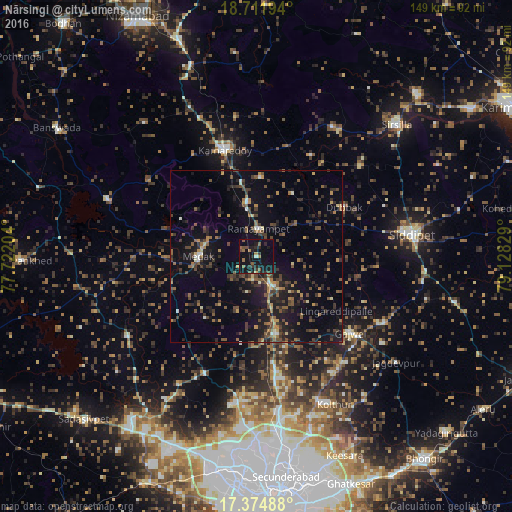
Analysis of Nārsingi night lights 2016
Square area 10x10 km:
 0%
0%90-99
0.87%80-89
0.43%70-79
0%60-69
4.55%50-59
5.41%40-49
3.03%30-39
3.68%20-29
6.71%10-19
30.74%0-9
44.59%Square area 50x50 km:
0.18%90-99
0.8%80-89
0.84%70-79
1.25%60-69
1.77%50-59
2.88%40-49
3.26%30-39
3.51%20-29
3.97%10-19
11.2%0-9
70.34%Clear (daylight) street map image can be seen on geolist.org.
Map coordinates:
18° 42' 43" North, 77° 43' 19.3" East
18° 2' 40.8" North, 78° 25' 30.6" East
17° 22' 29.6" North, 79° 7' 41.8" East
Some cities around Nārsingi sort by population:
• Sirsilla
55.8 km =34.7 mi,  46°
46°
• Kāmāreddi
31.9 km =19.8 mi,  343°
343°
• Siddipet
45.3 km =28.1 mi,  81°
81°
• Sangāreddi
58.9 km =36.6 mi,  217°
217°
• Patancheru
59.3 km =36.8 mi,  196°
196°
• Medak
17.4 km =10.8 mi,  270°
270°
• Andol
44.8 km =27.8 mi,  235°
235°
• Chandūr
39.2 km =24.4 mi, 241°
1261750 (p: 6,445)
Sources (retrieved 2019-11-25):
» Earth at Night: Flat Maps 2012, 2016