Naraini night lights from space
Night Light of Naraini (Madhya Pradesh) from space (India) Src. Average luminocity for 10x10km area is 7.0258% and for 50x50km: 3.3879%.
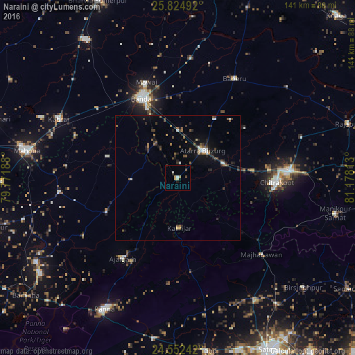
Analysis of Naraini night lights 2016
Square area 10x10 km:
 0.6%
0.6%90-99
1.19%80-89
0.6%70-79
1.59%60-69
0.79%50-59
0.79%40-49
0.79%30-39
0.6%20-29
1.19%10-19
1.39%0-9
90.48%Square area 50x50 km:
0.28%90-99
0.39%80-89
0.16%70-79
0.18%60-69
0.49%50-59
0.76%40-49
0.55%30-39
0.65%20-29
1.03%10-19
1.89%0-9
93.61%Clear (daylight) street map image can be seen on geolist.org.
Map coordinates:
25° 49' 29.7" North, 79° 46' 18.8" East
25° 11' 25.2" North, 80° 28' 30" East
24° 33' 8.7" North, 81° 10' 41.3" East
Some cities around Naraini sort by population:
• Bānda
34.9 km =21.7 mi,  336°
336°
• Atarra
14.4 km =8.9 mi,  42°
42°
• Baberu
45.9 km =28.5 mi,  30°
30°
• Ajaigarh
39 km =24.2 mi,  213°
213°
• Chandla
31.3 km =19.4 mi,  245°
245°
• Bisenda Buzurg
27.8 km =17.3 mi, 31°
• Mataundh
42.1 km =26.2 mi,  310°
310°
• Oran
33.4 km =20.8 mi,  53°
53°
1261871 (p: 15,077)
Sources (retrieved 2019-11-25):
» Earth at Night: Flat Maps 2012, 2016