Nagarukhra night lights from space
Night Light of Nagarukhra (West Bengal) from space (India) Src. Average luminocity for 10x10km area is 19.6528% and for 50x50km: 39.921%.
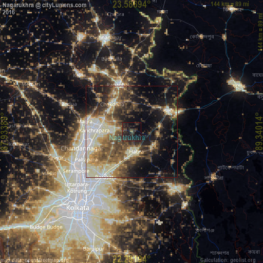
Analysis of Nagarukhra night lights 2016
Square area 10x10 km:
 0%
0%90-99
0%80-89
0%70-79
0%60-69
1.59%50-59
0.99%40-49
3.57%30-39
9.72%20-29
29.37%10-19
31.75%0-9
23.02%Square area 50x50 km:
2.98%90-99
10.65%80-89
4.68%70-79
3.93%60-69
5.62%50-59
7.61%40-49
8.7%30-39
8.08%20-29
9.77%10-19
15.11%0-9
22.86%Clear (daylight) street map image can be seen on geolist.org.
Map coordinates:
23° 35' 13" North, 87° 56' 2" East
22° 56' 27.6" North, 88° 38' 13.2" East
22° 17' 31" North, 89° 20' 24.5" East
Some cities around Nagarukhra sort by population:
• Hābra
11.2 km =7 mi,  169°
169°
• Kānchrāpāra
21.5 km =13.4 mi,  275°
275°
• Ashoknagar Kalyangarh
8.5 km =5.3 mi,  180°
180°
• Kalyani
16.4 km =10.2 mi,  286°
286°
• Gobārdānga
14 km =8.7 mi,  120°
120°
• Madanpur
16.5 km =10.3 mi,  295°
295°
• Haringhāta
6.9 km =4.3 mi, 292°
• Rāmchandrapur
17.3 km =10.7 mi,  253°
253°
11203603 (p: 13,548)
Sources (retrieved 2019-11-25):
» Earth at Night: Flat Maps 2012, 2016