Rāmchandrapur night lights from space
Night Light of Rāmchandrapur (West Bengal) from space (India) Src. Average luminocity for 10x10km area is 76.9464% and for 50x50km: 55.0162%.
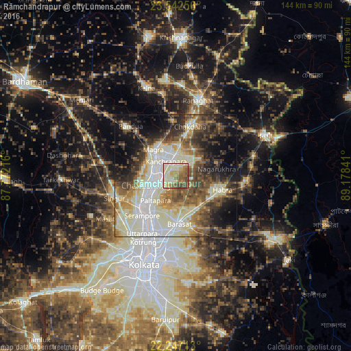
Analysis of Rāmchandrapur night lights 2016
Square area 10x10 km:
 4.37%
4.37%90-99
34.52%80-89
14.48%70-79
9.13%60-69
15.48%50-59
13.29%40-49
8.33%30-39
0.4%20-29
0%10-19
0%0-9
0%Square area 50x50 km:
9.14%90-99
18.18%80-89
6.82%70-79
4.89%60-69
6.67%50-59
7.77%40-49
8.52%30-39
7.74%20-29
8.51%10-19
11.24%0-9
10.53%Clear (daylight) street map image can be seen on geolist.org.
Map coordinates:
23° 32' 33.2" North, 87° 46' 19.8" East
22° 53' 47" North, 88° 28' 31" East
22° 14' 49.7" North, 89° 10' 42.3" East
Some cities around Rāmchandrapur sort by population:
• Bhātpāra
8.3 km =5.2 mi,  246°
246°
• Naihāti
6.2 km =3.9 mi,  267°
267°
• Hugli
8.2 km =5.1 mi,  279°
279°
• Kānchrāpāra
8.5 km =5.3 mi,  325°
325°
• Hālīsahar
7 km =4.3 mi,  304°
304°
• Bānsbāria
9.9 km =6.2 mi,  310°
310°
• Kalyani
9.7 km =6 mi,  4°
4°
• Sankarpur
5.9 km =3.7 mi,  204°
204°
1348600 (p: 9,664)
Sources (retrieved 2019-11-25):
» Earth at Night: Flat Maps 2012, 2016