Musāfir-Khāna night lights from space
Night Light of Musāfir-Khāna (Uttar Pradesh) from space (India) Src. Average luminocity for 10x10km area is 23.9867% and for 50x50km: 20.3849%.
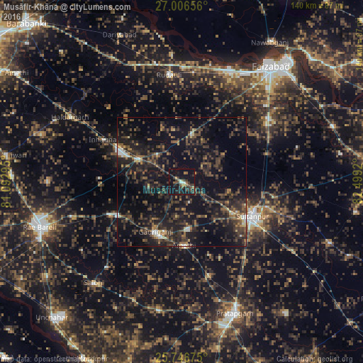
Analysis of Musāfir-Khāna night lights 2016
Square area 10x10 km:
 1.33%
1.33%90-99
1.7%80-89
1.33%70-79
1.7%60-69
3.22%50-59
3.22%40-49
5.68%30-39
9.28%20-29
11.55%10-19
39.96%0-9
21.02%Square area 50x50 km:
0.63%90-99
1.23%80-89
1%70-79
1.13%60-69
2.43%50-59
3.97%40-49
5.79%30-39
7.75%20-29
10.95%10-19
24.14%0-9
40.98%Clear (daylight) street map image can be seen on geolist.org.
Map coordinates:
27° 0' 23.6" North, 81° 5' 34.6" East
26° 22' 42.1" North, 81° 47' 45.9" East
25° 44' 48.3" North, 82° 29' 57.1" East
Some cities around Musāfir-Khāna sort by population:
• Sultānpur
30.7 km =19.1 mi,  115°
115°
• Jais
27.7 km =17.2 mi,  242°
242°
• Lālganj
50.5 km =31.4 mi,  190°
190°
• Salon
51.7 km =32.1 mi,  221°
221°
• Amethī
24.6 km =15.3 mi,  177°
177°
• Bīkāpur
41.3 km =25.7 mi,  54°
54°
• Parshādepur
45.5 km =28.3 mi, 221°
• Antu
37.3 km =23.2 mi,  163°
163°
1262392 (p: 8,081)
Sources (retrieved 2019-11-25):
» Earth at Night: Flat Maps 2012, 2016