Mūlki night lights from space
Night Light of Mūlki (Karnataka) from space (India) Src. Average luminocity for 10x10km area is 23.1104% and for 50x50km: 15.4429%.
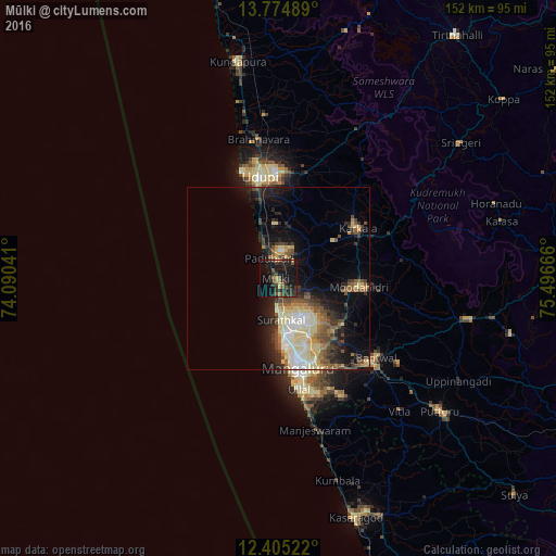
Analysis of Mūlki night lights 2016
Square area 10x10 km:
 0%
0%90-99
0%80-89
1.73%70-79
3.03%60-69
3.03%50-59
3.68%40-49
4.98%30-39
10.61%20-29
11.69%10-19
40.91%0-9
20.35%Square area 50x50 km:
1.59%90-99
2.64%80-89
3.22%70-79
1.39%60-69
1.59%50-59
2.38%40-49
2.79%30-39
2.63%20-29
4.01%10-19
8.52%0-9
69.23%Clear (daylight) street map image can be seen on geolist.org.
Map coordinates:
13° 46' 29.6" North, 74° 5' 25.5" East
13° 5' 27.6" North, 74° 47' 36.7" East
12° 24' 18.8" North, 75° 29' 48" East
Some cities around Mūlki sort by population:
• Mangalore
20.5 km =12.7 mi,  160°
160°
• Udupi
27.6 km =17.1 mi,  349°
349°
• Ullal
32.5 km =20.2 mi,  167°
167°
• Bantvāl
34.4 km =21.4 mi,  130°
130°
• Manipal
28.8 km =17.9 mi,  357°
357°
• Mūdbidri
22 km =13.7 mi,  97°
97°
• Kārkala
25.5 km =15.8 mi,  57°
57°
• Malpe
30.3 km =18.8 mi,  341°
341°
1262546 (p: 17,259)
Sources (retrieved 2019-11-25):
» Earth at Night: Flat Maps 2012, 2016