Kodumudi night lights from space
Night Light of Kodumudi (Tamil Nadu) from space (India) Src. Average luminocity for 10x10km area is 11.4329% and for 50x50km: 13.2261%.
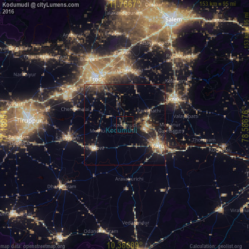
Analysis of Kodumudi night lights 2016
Square area 10x10 km:
 0%
0%90-99
0%80-89
0%70-79
0.43%60-69
0.43%50-59
4.11%40-49
4.55%30-39
2.6%20-29
10.39%10-19
3.46%0-9
74.03%Square area 50x50 km:
0.11%90-99
0.84%80-89
1.47%70-79
1.73%60-69
1.61%50-59
2.38%40-49
3.74%30-39
3.53%20-29
6.34%10-19
10.14%0-9
68.11%Clear (daylight) street map image can be seen on geolist.org.
Map coordinates:
11° 46' 0.1" North, 77° 10' 49.8" East
11° 4' 39" North, 77° 53' 1.1" East
10° 23' 12.1" North, 78° 35' 12.3" East
Some cities around Kodumudi sort by population:
• Erode
34.1 km =21.2 mi,  329°
329°
• Tiruchengode
33.7 km =20.9 mi,  2°
2°
• Karur
25.3 km =15.7 mi,  121°
121°
• Nāmakkal
34.6 km =21.5 mi,  62°
62°
• Velur
13.3 km =8.3 mi,  75°
75°
• Sivagiri
11.5 km =7.1 mi,  294°
294°
• Chennimalai
32 km =19.9 mi, 287°
• Mohanūr
28 km =17.4 mi,  94°
94°
1266387 (p: 13,053)
Sources (retrieved 2019-11-25):
» Earth at Night: Flat Maps 2012, 2016