Sivagiri night lights from space
Night Light of Sivagiri (Tamil Nadu) from space (India) Src. Average luminocity for 10x10km area is 7.7294% and for 50x50km: 16.4646%.
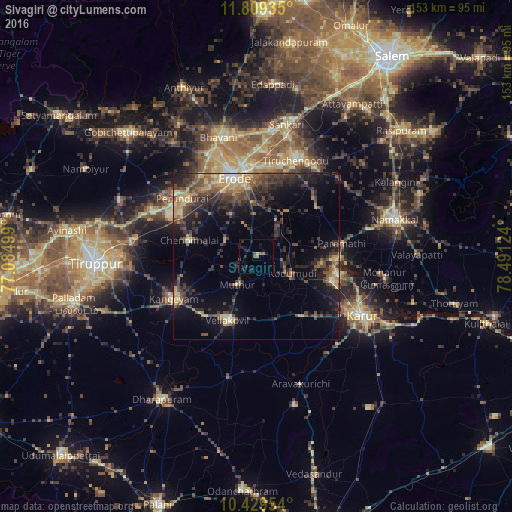
Analysis of Sivagiri night lights 2016
Square area 10x10 km:
 0%
0%90-99
0%80-89
0.87%70-79
0%60-69
1.73%50-59
2.81%40-49
0.22%30-39
0.22%20-29
6.93%10-19
6.06%0-9
81.17%Square area 50x50 km:
0.3%90-99
1.19%80-89
2.54%70-79
2.1%60-69
2.1%50-59
2.76%40-49
4.62%30-39
4.65%20-29
7.13%10-19
10.49%0-9
62.12%Clear (daylight) street map image can be seen on geolist.org.
Map coordinates:
11° 48' 33.7" North, 77° 5' 6" East
11° 7' 12.9" North, 77° 47' 17.2" East
10° 25' 46.3" North, 78° 29' 28.5" East
Some cities around Sivagiri sort by population:
• Erode
25.6 km =15.9 mi,  345°
345°
• Tiruchengode
31.1 km =19.3 mi,  21°
21°
• Kangayam
27.9 km =17.3 mi,  242°
242°
• Velur
23.3 km =14.5 mi,  93°
93°
• Perundurai
27.8 km =17.3 mi,  308°
308°
• Chennimalai
20.7 km =12.9 mi,  283°
283°
• Kodumudi
11.5 km =7.1 mi,  114°
114°
• Vijayapuri
34.3 km =21.3 mi,  293°
293°
1255950 (p: 16,779)
Sources (retrieved 2019-11-25):
» Earth at Night: Flat Maps 2012, 2016