Māttūr night lights from space
Night Light of Māttūr (Tamil Nadu) from space (India) Src. Average luminocity for 10x10km area is 15.1948% and for 50x50km: 9.3381%.
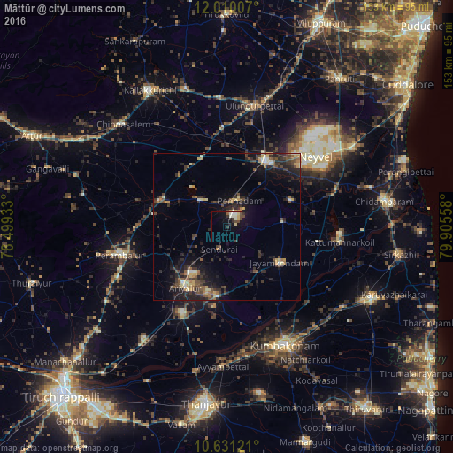
Analysis of Māttūr night lights 2016
Square area 10x10 km:
 0.43%
0.43%90-99
5.63%80-89
2.38%70-79
1.08%60-69
0%50-59
0.87%40-49
3.03%30-39
2.16%20-29
3.03%10-19
9.52%0-9
71.86%Square area 50x50 km:
0.13%90-99
1.18%80-89
1.09%70-79
1.07%60-69
0.91%50-59
1.5%40-49
2.36%30-39
2.46%20-29
3.96%10-19
6.87%0-9
78.47%Clear (daylight) street map image can be seen on geolist.org.
Map coordinates:
12° 0' 36.3" North, 78° 29' 57.6" East
11° 19' 17.3" North, 79° 12' 8.8" East
10° 37' 52.4" North, 79° 54' 20.1" East
Some cities around Māttūr sort by population:
• Vriddhāchalam
25.6 km =15.9 mi,  31°
31°
• Jayamkondacholapuram
21.3 km =13.2 mi,  124°
124°
• Perambalur
36.2 km =22.5 mi,  254°
254°
• Ariyalūr
24.6 km =15.3 mi,  214°
214°
• Pennādam
10.1 km =6.3 mi,  24°
24°
• Papanasam
44.5 km =27.7 mi,  170°
170°
• Srīmushnam
23.7 km =14.7 mi,  68°
68°
• Swāmimalai
42.8 km =26.6 mi,  161°
161°
1263324 (p: 5,605)
Sources (retrieved 2019-11-25):
» Earth at Night: Flat Maps 2012, 2016