Papanasam night lights from space
Night Light of Papanasam (Tamil Nadu) from space (India) Src. Average luminocity for 10x10km area is 19.4221% and for 50x50km: 14.5524%.
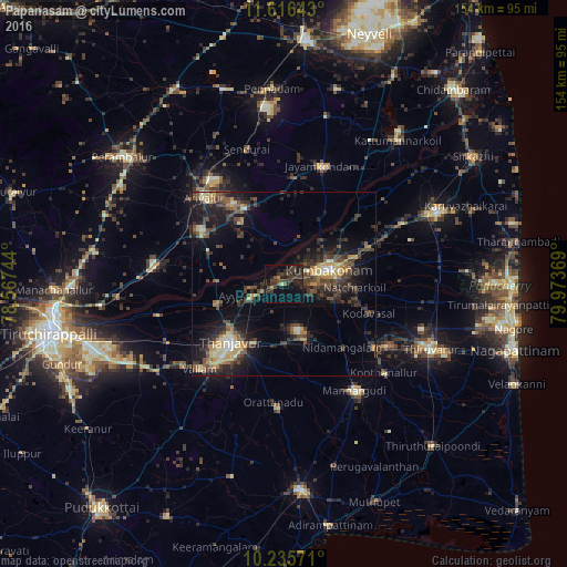
Analysis of Papanasam night lights 2016
Square area 10x10 km:
 0%
0%90-99
0.22%80-89
0.65%70-79
0.65%60-69
1.08%50-59
1.73%40-49
8.23%30-39
16.23%20-29
9.74%10-19
16.88%0-9
44.59%Square area 50x50 km:
0.34%90-99
1.38%80-89
1.81%70-79
2.04%60-69
1.59%50-59
1.95%40-49
4.11%30-39
4.74%20-29
5.58%10-19
10.38%0-9
66.07%Clear (daylight) street map image can be seen on geolist.org.
Map coordinates:
11° 36' 59.1" North, 78° 34' 2.8" East
10° 55' 36.7" North, 79° 16' 14" East
10° 14' 8.6" North, 79° 58' 25.3" East
Some cities around Papanasam sort by population:
• Tanjore
21.3 km =13.2 mi,  222°
222°
• Kumbakonam
13.7 km =8.5 mi,  73°
73°
• Ayyampettāi
10.3 km =6.4 mi,  254°
254°
• Ammāpettai
15.6 km =9.7 mi,  159°
159°
• Thiruvaiyaru
18.8 km =11.7 mi,  255°
255°
• Thiruvidaimaruthur
21.4 km =13.3 mi, 68°
• Valangaiman
14 km =8.7 mi,  106°
106°
• Swāmimalai
7.3 km =4.5 mi,  62°
62°
1260417 (p: 16,837)
Sources (retrieved 2019-11-25):
» Earth at Night: Flat Maps 2012, 2016