Swāmimalai night lights from space
Night Light of Swāmimalai (Tamil Nadu) from space (India) Src. Average luminocity for 10x10km area is 38.2446% and for 50x50km: 12.8861%.
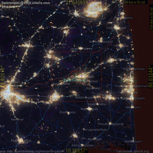
Analysis of Swāmimalai night lights 2016
Square area 10x10 km:
 0.87%
0.87%90-99
3.68%80-89
4.76%70-79
6.28%60-69
4.11%50-59
5.19%40-49
10.17%30-39
22.29%20-29
18.83%10-19
18.18%0-9
5.63%Square area 50x50 km:
0.32%90-99
1.16%80-89
1.34%70-79
1.75%60-69
1.26%50-59
1.84%40-49
3.74%30-39
4.59%20-29
5.31%10-19
8.51%0-9
70.18%Clear (daylight) street map image can be seen on geolist.org.
Map coordinates:
11° 38' 49" North, 78° 37' 34.3" East
10° 57' 26.9" North, 79° 19' 45.5" East
10° 15' 58.9" North, 80° 1' 56.8" East
Some cities around Swāmimalai sort by population:
• Kumbakonam
6.8 km =4.2 mi,  85°
85°
• Papanasam
7.3 km =4.5 mi,  242°
242°
• Ayyampettāi
17.5 km =10.9 mi,  249°
249°
• Ammāpettai
18.1 km =11.2 mi,  183°
183°
• Thiruvidaimaruthur
14.2 km =8.8 mi,  71°
71°
• Valangaiman
10.2 km =6.3 mi,  137°
137°
• Aduthurai
17.8 km =11.1 mi, 68°
• Needamangalam
22.6 km =14 mi,  154°
154°
1255283 (p: 7,197)
Sources (retrieved 2019-11-25):
» Earth at Night: Flat Maps 2012, 2016