Mālpur night lights from space
Night Light of Mālpur (Gujarat) from space (India) Src. Average luminocity for 10x10km area is 1.8333% and for 50x50km: 2.2429%.
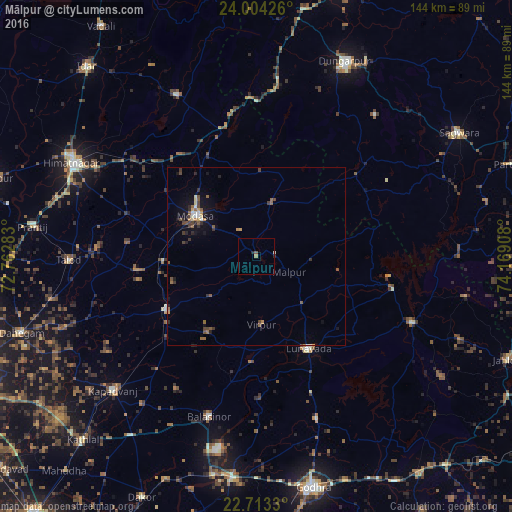
Analysis of Mālpur night lights 2016
Square area 10x10 km:
 0%
0%90-99
0.38%80-89
0%70-79
0.19%60-69
0.57%50-59
0.76%40-49
0%30-39
0%20-29
1.14%10-19
0%0-9
96.97%Square area 50x50 km:
0.02%90-99
0.3%80-89
0.16%70-79
0.26%60-69
0.34%50-59
0.6%40-49
0.39%30-39
0.52%20-29
0.48%10-19
1.51%0-9
95.43%Clear (daylight) street map image can be seen on geolist.org.
Map coordinates:
24° 0' 15.3" North, 72° 45' 46.2" East
23° 21' 37.3" North, 73° 27' 57.4" East
22° 42' 47.9" North, 74° 10' 8.7" East
Some cities around Mālpur sort by population:
• Himatnagar
57.5 km =35.7 mi,  297°
297°
• Modāsa
20.5 km =12.7 mi, 303°
• Dūngarpur
59.4 km =36.9 mi,  25°
25°
• Kapadvanj
55.1 km =34.2 mi,  227°
227°
• Lūnāvāda
29.7 km =18.5 mi,  150°
150°
• Meghraj
16.1 km =10 mi,  17°
17°
• Virpur
19.1 km =11.9 mi,  175°
175°
• Galiākot
59.3 km =36.8 mi,  72°
72°
1264033 (p: 6,971)
Sources (retrieved 2019-11-25):
» Earth at Night: Flat Maps 2012, 2016