Lakhipur night lights from space
Night Light of Lakhipur (Assam) from space (India) Src. Average luminocity for 10x10km area is 8.9881% and for 50x50km: 4.2558%.
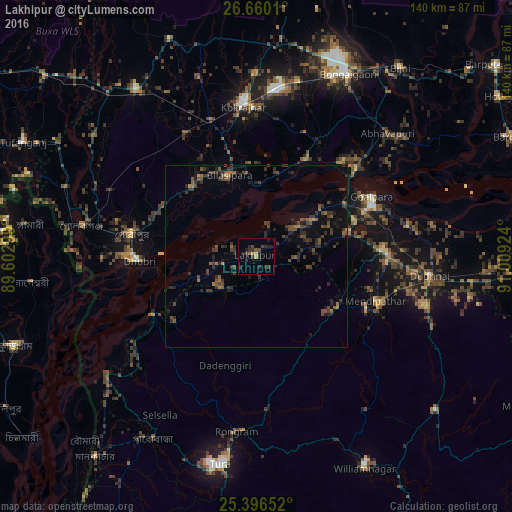
Analysis of Lakhipur night lights 2016
Square area 10x10 km:
 0%
0%90-99
0%80-89
0.79%70-79
0.6%60-69
0.99%50-59
1.19%40-49
3.77%30-39
2.18%20-29
8.33%10-19
3.17%0-9
78.97%Square area 50x50 km:
0%90-99
0%80-89
0.06%70-79
0.17%60-69
0.58%50-59
1.04%40-49
1.55%30-39
1.9%20-29
2.13%10-19
2.45%0-9
90.12%Clear (daylight) street map image can be seen on geolist.org.
Map coordinates:
26° 39' 36.4" North, 89° 36' 10.8" East
26° 1' 48" North, 90° 18' 22" East
25° 23' 47.5" North, 91° 0' 33.3" East
Some cities around Lakhipur sort by population:
• Dhuburi
32 km =19.9 mi,  267°
267°
• Goālpāra
35.9 km =22.3 mi,  62°
62°
• Bilāsipāra
23.7 km =14.7 mi,  342°
342°
• Kokrajhar
41.4 km =25.7 mi,  355°
355°
• Gauripur
35 km =21.7 mi,  279°
279°
• Chāpar
30.4 km =18.9 mi,  27°
27°
• Sapatgrām
38.7 km =24 mi,  331°
331°
• Golakganj
48.9 km =30.4 mi, 279°
1265239 (p: 14,045)
Sources (retrieved 2019-11-25):
» Earth at Night: Flat Maps 2012, 2016