Golakganj night lights from space
Night Light of Golakganj (Assam) from space (India) Src. Average luminocity for 10x10km area is 8.1825% and for 50x50km: 5.8031%.
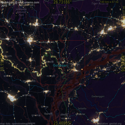
Analysis of Golakganj night lights 2016
Square area 10x10 km:
 0%
0%90-99
0%80-89
0%70-79
0%60-69
1.79%50-59
2.98%40-49
3.17%30-39
2.38%20-29
3.97%10-19
2.78%0-9
82.94%Square area 50x50 km:
0.14%90-99
0.26%80-89
0.45%70-79
0.66%60-69
0.87%50-59
1.09%40-49
1.73%30-39
1.55%20-29
1.9%10-19
2.9%0-9
88.44%Clear (daylight) street map image can be seen on geolist.org.
Map coordinates:
26° 43' 54.7" North, 89° 7' 10.7" East
26° 6' 7.8" North, 89° 49' 21.9" East
25° 28' 8.6" North, 90° 31' 33.2" East
Some cities around Golakganj sort by population:
• Lalmonirhat, BD
42.9 km =26.7 mi,  241°
241°
• Dhuburi
18.7 km =11.6 mi,  119°
119°
• Nageswari, BD
19.8 km =12.3 mi,  221°
221°
• Dīnhāta
36.3 km =22.6 mi,  275°
275°
• Gauripur
14 km =8.7 mi,  98°
98°
• Tufānganj
28.6 km =17.8 mi,  326°
326°
• Goshaingaon
40 km =24.9 mi,  20°
20°
• Sapatgrām
39.8 km =24.7 mi,  48°
48°
1271047 (p: 8,124)
Sources (retrieved 2019-11-25):
» Earth at Night: Flat Maps 2012, 2016