Kupwāra night lights from space
Night Light of Kupwāra (Jammu and Kashmir) from space (India) Src. Average luminocity for 10x10km area is 0% and for 50x50km: 3.6773%.
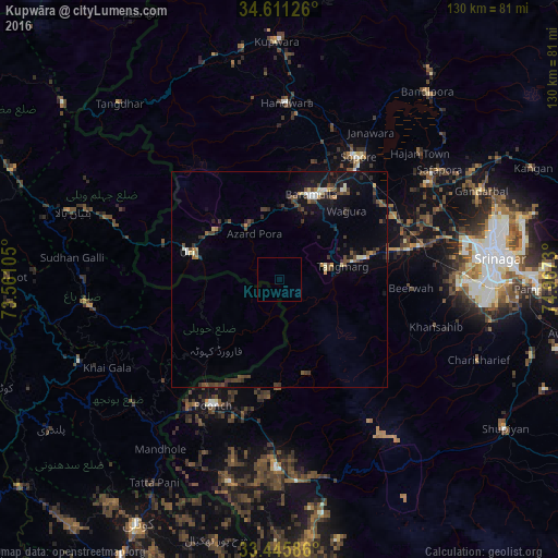
Analysis of Kupwāra night lights 2016
Square area 10x10 km:
100  0%
0%
90-99 0%
80-89 0%
70-79 0%
60-69 0%
50-59 0%
40-49 0%
30-39 0%
20-29 0%
10-19 0%
0-9 100%
0%90-99
0%80-89
0%70-79
0%60-69
0%50-59
0%40-49
0%30-39
0%20-29
0%10-19
0%0-9
100%Square area 50x50 km:
100 0.14%
90-99 0.45%
80-89 0.27%
70-79 0.31%
60-69 0.25%
50-59 0.52%
40-49 1.16%
30-39 0.94%
20-29 1.03%
10-19 2.69%
0-9 92.24%
0.14%90-99
0.45%80-89
0.27%70-79
0.31%60-69
0.25%50-59
0.52%40-49
1.16%30-39
0.94%20-29
1.03%10-19
2.69%0-9
92.24%Clear (daylight) street map image can be seen on geolist.org.
Map coordinates:
34° 36' 40.5" North, 73° 33' 39.8" East
34° 1' 50" North, 74° 15' 51" East
33° 26' 45.1" North, 74° 58' 2.3" East
Some cities around Kupwāra sort by population:
• Soyībug
41 km =25.5 mi,  82°
82°
• Bāramūla
21.1 km =13.1 mi,  20°
20°
• Sopur
34.3 km =21.3 mi,  33°
33°
• Pūnch
33 km =20.5 mi,  208°
208°
• Pattan
30.6 km =19 mi,  61°
61°
• Sumbal
41.7 km =25.9 mi, 57°
• Hājan
44.1 km =27.4 mi,  47°
47°
• Uri
20.4 km =12.7 mi,  285°
285°
6268046 (p: 14,711)
Sources (retrieved 2019-11-25):
» Earth at Night: Flat Maps 2012, 2016