Kovalam night lights from space
Night Light of Kovalam (Kerala) from space (India) Src. Average luminocity for 10x10km area is 18.4194% and for 50x50km: 13.113%.
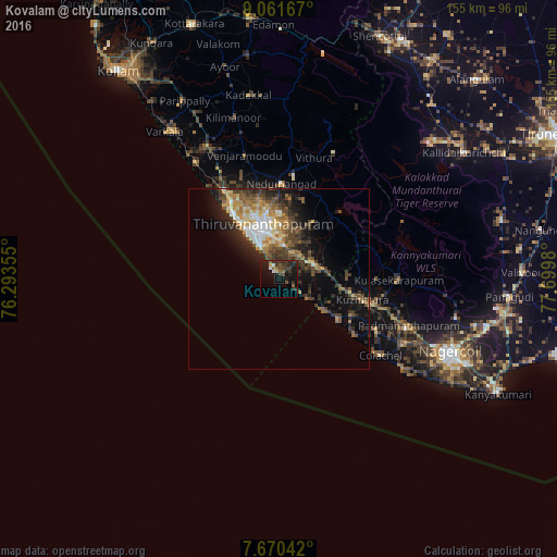
Analysis of Kovalam night lights 2016
Square area 10x10 km:
 1.24%
1.24%90-99
1.24%80-89
0.62%70-79
1.03%60-69
2.69%50-59
3.31%40-49
3.1%30-39
10.54%20-29
7.85%10-19
18.39%0-9
50%Square area 50x50 km:
1.15%90-99
1.92%80-89
1.67%70-79
1.73%60-69
2.05%50-59
1.83%40-49
3.03%30-39
3.06%20-29
3.98%10-19
6.75%0-9
72.82%Clear (daylight) street map image can be seen on geolist.org.
Map coordinates:
9° 3' 42" North, 76° 17' 36.8" East
8° 22' 0" North, 76° 59' 48" East
7° 40' 13.5" North, 77° 41' 59.3" East
Some cities around Kovalam sort by population:
• Thiruvananthapuram
14.2 km =8.8 mi,  338°
338°
• Neyyāttinkara
10.4 km =6.5 mi,  70°
70°
• Nedumangād
26.2 km =16.3 mi,  1°
1°
• Attingal
41.7 km =25.9 mi,  331°
331°
• Colachel
35.5 km =22.1 mi,  125°
125°
• Kuzhithurai
22.2 km =13.8 mi,  104°
104°
• Padmanābhapuram
38.7 km =24 mi,  110°
110°
• Eraniel
39.5 km =24.5 mi,  116°
116°
1265896 (p: 6,000)
Sources (retrieved 2019-11-25):
» Earth at Night: Flat Maps 2012, 2016