Kotapārh night lights from space
Night Light of Kotapārh (Chhattisgarh) from space (India) Src. Average luminocity for 10x10km area is 3.0887% and for 50x50km: 3.5835%.
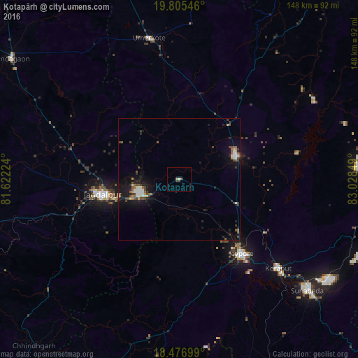
Analysis of Kotapārh night lights 2016
Square area 10x10 km:
 0.87%
0.87%90-99
0%80-89
0%70-79
0.87%60-69
0.87%50-59
0%40-49
0.87%30-39
0.87%20-29
0%10-19
0%0-9
95.67%Square area 50x50 km:
0.42%90-99
0.58%80-89
0.23%70-79
0.3%60-69
0.34%50-59
0.6%40-49
0.68%30-39
0.73%20-29
0.59%10-19
3.5%0-9
92.04%Clear (daylight) street map image can be seen on geolist.org.
Map coordinates:
19° 48' 19.7" North, 81° 37' 20.1" East
19° 8' 33.2" North, 82° 19' 31.3" East
18° 28' 37.2" North, 83° 1' 42.6" East
Some cities around Kotapārh sort by population:
• Nowrangapur
25.4 km =15.8 mi,  67°
67°
• Jeypore
41 km =25.5 mi,  140°
140°
• Jagdalpur
32.7 km =20.3 mi,  257°
257°
• Korāput
54.7 km =34 mi,  132°
132°
• Kondagaon
85.4 km =53.1 mi,  305°
305°
• Umarkot
59.4 km =36.9 mi,  347°
347°
• Malakanagiri
98 km =60.9 mi,  208°
208°
• Gīdam
99.1 km =61.6 mi, 259°
1266029 (p: 15,479)
Sources (retrieved 2019-11-25):
» Earth at Night: Flat Maps 2012, 2016