Konnūr night lights from space
Night Light of Konnūr (Karnataka) from space (India) Src. Average luminocity for 10x10km area is 22.3533% and for 50x50km: 5.873%.
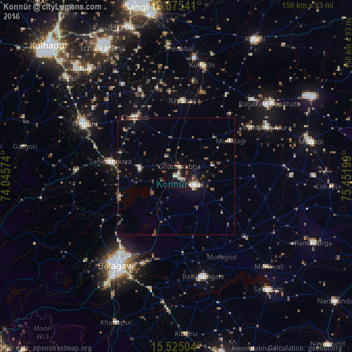
Analysis of Konnūr night lights 2016
Square area 10x10 km:
 0.41%
0.41%90-99
5.58%80-89
3.1%70-79
0.83%60-69
3.93%50-59
2.48%40-49
2.89%30-39
3.72%20-29
1.65%10-19
31.61%0-9
43.8%Square area 50x50 km:
0.31%90-99
0.75%80-89
0.56%70-79
0.34%60-69
0.95%50-59
0.76%40-49
1.22%30-39
1.41%20-29
1.02%10-19
4.18%0-9
88.49%Clear (daylight) street map image can be seen on geolist.org.
Map coordinates:
16° 52' 31.5" North, 74° 2' 44.7" East
16° 12' 5" North, 74° 44' 55.9" East
15° 31' 30.1" North, 75° 27' 7.2" East
Some cities around Konnūr sort by population:
• Gokak
8.8 km =5.5 mi,  114°
114°
• Bail-Hongal
44.7 km =27.8 mi,  164°
164°
• Chikodi
30.7 km =19.1 mi,  325°
325°
• Sankeshwar
29.1 km =18.1 mi,  282°
282°
• Mahālingpur
43.7 km =27.2 mi,  61°
61°
• Gadhinglaj
42.6 km =26.5 mi,  273°
273°
• Hukeri
16 km =9.9 mi, 281°
• Rāybāg
32.4 km =20.1 mi,  4°
4°
1266178 (p: 19,166)
Sources (retrieved 2019-11-25):
» Earth at Night: Flat Maps 2012, 2016