Ammāpettai night lights from space
Night Light of Ammāpettai (Tamil Nadu) from space (India) Src. Average luminocity for 10x10km area is 20.2879% and for 50x50km: 28.5739%.
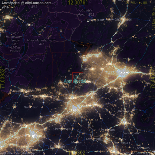
Analysis of Ammāpettai night lights 2016
Square area 10x10 km:
 0%
0%90-99
0%80-89
0%70-79
0%60-69
0.22%50-59
3.46%40-49
9.96%30-39
11.47%20-29
20.35%10-19
24.46%0-9
30.09%Square area 50x50 km:
0.09%90-99
2.12%80-89
3.56%70-79
3.04%60-69
5.42%50-59
9.76%40-49
10.55%30-39
8.57%20-29
8.59%10-19
14.95%0-9
33.35%Clear (daylight) street map image can be seen on geolist.org.
Map coordinates:
12° 18' 27.4" North, 77° 2' 22.3" East
11° 37' 11.1" North, 77° 44' 33.5" East
10° 55' 48.7" North, 78° 26' 44.8" East
Some cities around Ammāpettai sort by population:
• Mettur
19.7 km =12.2 mi,  18°
18°
• Idappadi
11.1 km =6.9 mi,  109°
109°
• Bhavāni
20.5 km =12.7 mi,  198°
198°
• Tāramangalam
26.1 km =16.2 mi,  71°
71°
• Anthiyur
17.3 km =10.7 mi,  253°
253°
• Jalakandapuram
16.6 km =10.3 mi,  58°
58°
• Nangavalli
22.6 km =14 mi,  45°
45°
• Konganāpuram
18 km =11.2 mi, 107°
1278751 (p: 8,552)
Sources (retrieved 2019-11-25):
» Earth at Night: Flat Maps 2012, 2016