Chennimalai night lights from space
Night Light of Chennimalai (Tamil Nadu) from space (India) Src. Average luminocity for 10x10km area is 17.1775% and for 50x50km: 24.0894%.
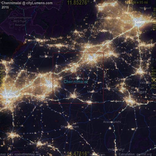
Analysis of Chennimalai night lights 2016
Square area 10x10 km:
 0%
0%90-99
1.73%80-89
1.73%70-79
1.08%60-69
1.3%50-59
3.25%40-49
3.9%30-39
5.63%20-29
8.44%10-19
20.56%0-9
52.38%Square area 50x50 km:
0.51%90-99
2.46%80-89
4.6%70-79
3.93%60-69
3.48%50-59
4.43%40-49
6.16%30-39
6.18%20-29
7.58%10-19
12.06%0-9
48.61%Clear (daylight) street map image can be seen on geolist.org.
Map coordinates:
11° 51' 9.9" North, 76° 54' 2.7" East
11° 9' 49.6" North, 77° 36' 14" East
10° 28' 23.4" North, 78° 18' 25.2" East
Some cities around Chennimalai sort by population:
• Tiruppur
27.7 km =17.2 mi,  258°
258°
• Erode
24 km =14.9 mi,  34°
34°
• Kangayam
18.2 km =11.3 mi,  194°
194°
• Perundurai
12.6 km =7.8 mi,  352°
352°
• Sivagiri
20.7 km =12.9 mi,  103°
103°
• Kodumudi
32 km =19.9 mi,  107°
107°
• Ūttukkuli
16.3 km =10.1 mi,  272°
272°
• Vijayapuri
14.5 km =9 mi,  308°
308°
1274422 (p: 16,268)
Sources (retrieved 2019-11-25):
» Earth at Night: Flat Maps 2012, 2016